IMAGES TAKEN NEAR TO
Amelia Close, PORTLAND, DT5 1HE
Introduction
This page details the photographs taken nearby to Amelia Close, DT5 1HE by members of the Geograph project.
The Geograph project started in 2005 with the aim of publishing, organising and preserving representative images for every square kilometre of Great Britain, Ireland and the Isle of Man.

There are currently over 7.5m images from over14,400 individuals and you can help contribute to the project by visiting https://www.geograph.org.uk
Image Map
Images are licensed for reuse under creativecommons.org/licenses/by-sa/2.0
Notes
- Clicking on the map will re-center to the selected point.
- The higher the marker number, the further away the image location is from the centre of the postcode.
Image Listing (35 Images Found)
Images are licensed for reuse under creativecommons.org/licenses/by-sa/2.0
Image
Details
Distance
1
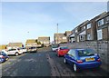
Fortuneswell, Amelia Close
A cul-de-sac off East Weare Road, part of a large housing development between Fortuneswell and Castletown.
Image: © Mike Faherty
Taken: 24 Jan 2015
0.04 miles
3
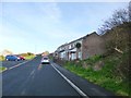
Fortuneswell, Amelia Close
Part of a large housing development between Fortuneswell and Castletown.
Image: © Mike Faherty
Taken: 24 Jan 2015
0.07 miles
4
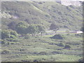
Cattle on the steep slope of The Verne 1962
Bottom left is the naval cemetery and Portland Harbour beyond.
Image: © Gordon Spicer
Taken: Unknown
0.08 miles
5
Castletown, memorial
To seven sailors who died in naval service on Portland.
Image: © Mike Faherty
Taken: 24 Jan 2015
0.09 miles
6

Castletown, war memorial
To those fallen in WWI and WWII; surrounded by war graves, and in the shadow of Verne Cliff.
Image: © Mike Faherty
Taken: 24 Jan 2015
0.09 miles
7
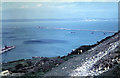
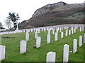
Cemetery from dockyard. Portland
The local cemetery as seen from a ship in the dockyard.
Image: © Jacko
Taken: 16 May 2009
0.09 miles
8
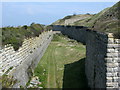
Moat surrounding the Verne Citadel, Portland
The Victorian defence works have been supplemented by some newer additions for HM Prison The Verne
Image: © Simon Palmer
Taken: 20 Apr 2008
0.10 miles
9
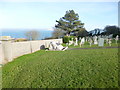
Navy cemetery, Portland
The cemetery sits on the northern slopes of the island under the steep cliffs
Image: © Nigel Mykura
Taken: 24 Mar 2008
0.11 miles
10
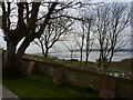
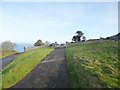
Trees, Portland
The view over Portland Harbour and up the fleet beyond is magnificent but omnipresent from the higher levels of this part of Portland. The presence of trees however is a lot rarer, owing to the high level of exposure of the island. These are to be found by the northern boundary wall of the naval cemetery. More trees exist further south by a bowls club Image .
Image: © Ivan Hall
Taken: 11 Apr 2010
0.11 miles