IMAGES TAKEN NEAR TO
Ventnor Lane, PORTLAND, DT5 1FY
Introduction
This page details the photographs taken nearby to Ventnor Lane, DT5 1FY by members of the Geograph project.
The Geograph project started in 2005 with the aim of publishing, organising and preserving representative images for every square kilometre of Great Britain, Ireland and the Isle of Man.

There are currently over 7.5m images from over14,400 individuals and you can help contribute to the project by visiting https://www.geograph.org.uk
Image Map
Images are licensed for reuse under creativecommons.org/licenses/by-sa/2.0
Notes
- Clicking on the map will re-center to the selected point.
- The higher the marker number, the further away the image location is from the centre of the postcode.
Image Listing (269 Images Found)
Images are licensed for reuse under creativecommons.org/licenses/by-sa/2.0
Image
Details
Distance
1
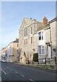
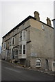
Fortuneswell, Royal Manor Theatre
On Fortuneswell (the street); formerly a Methodist church, now a theatre. The latest billboard on display refers to Aug. 14; perhaps the theatre is no more. http://www.royalmanortheatre.co.uk/#!about/c1x9v
Image: © Mike Faherty
Taken: 24 Jan 2015
0.02 miles
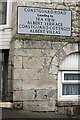
2

Benchmark on #131 Fortuneswell
Ordnance Survey cut mark benchmark described on the Bench Mark Database at http://www.bench-marks.org.uk/bm40271
Image: © Roger Templeman
Taken: 21 Nov 2011
0.03 miles
3
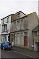
#131 Fortuneswell
There is an OS benchmark Image to the right of the steps to the red door.
Image: © Roger Templeman
Taken: 21 Nov 2011
0.03 miles
4
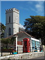
Portland: phone box at Fortuneswell
A traditional K6 phone box stands on the main street, Fortuneswell, through the main town of Portland which is also known as Fortuneswell. The church of St. John the Baptist stands prominently in the background.
Image: © Chris Downer
Taken: 7 Sep 2013
0.04 miles
5
Fortuneswell from Verne Wells viewpoint
Image: © Steve Daniels
Taken: 8 Jun 2007
0.04 miles
6
Benchmark on the side of #115 Fortuneswell
Ordnance Survey cut mark benchmark described on the Bench Mark Database at http://www.bench-marks.org.uk/bm40269
Image: © Roger Templeman
Taken: 21 Nov 2011
0.04 miles
7
#115 Fortuneswell
There is an OS benchmark Image below the road name sign on the side of the house
Image: © Roger Templeman
Taken: 21 Nov 2011
0.04 miles
8
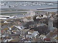
Fortuneswell from Portland Heights
View from the War Memorial over Fortuneswell with the new marina at Osprey Quay in the background.
http://en.wikipedia.org/wiki/Isle_of_Portland
Image: © Colin Smith
Taken: 14 Jan 2012
0.05 miles
10
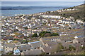
![Portland and Chesil Beach [5]](https://s3.geograph.org.uk/geophotos/06/78/29/6782995_beee2e18_120x120.jpg)
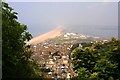
Portland and Chesil Beach [5]
This view from near the Olympic Rings Image looks over Fortuneswell towards Portland Harbour. The tower of the church of St John is prominent.
The Isle of Portland is a tied island, some 5 miles south of the resort of Weymouth, the southernmost point of the county of Dorset, joined to the mainland by Chesil Beach. The Isle has been inhabited since at least the Mesolithic period. Portland stone, a limestone famous for its use in world architecture is quarried here. Portland Harbour, is one of the largest man-made harbours in the world. Chesil Beach, a barrier beach, runs for 18 miles from West Bay to the Isle of Portland and in places is 50 feet high and 650 feet wide.
Image: © Michael Dibb
Taken: 11 Dec 2020
0.05 miles