IMAGES TAKEN NEAR TO
Mulberry Avenue, PORTLAND, DT5 1FT
Introduction
This page details the photographs taken nearby to Mulberry Avenue, DT5 1FT by members of the Geograph project.
The Geograph project started in 2005 with the aim of publishing, organising and preserving representative images for every square kilometre of Great Britain, Ireland and the Isle of Man.

There are currently over 7.5m images from over14,400 individuals and you can help contribute to the project by visiting https://www.geograph.org.uk
Image Map
Images are licensed for reuse under creativecommons.org/licenses/by-sa/2.0
Notes
- Clicking on the map will re-center to the selected point.
- The higher the marker number, the further away the image location is from the centre of the postcode.
Image Listing (193 Images Found)
Images are licensed for reuse under creativecommons.org/licenses/by-sa/2.0
Image
Details
Distance
1
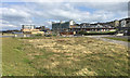
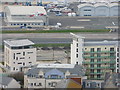
Mixed development near Osprey Quay, Portland
Former naval land at the flat northwest end of Portland appears to be developing in a piecemeal way. Roads such as Lerret Road, left, have been laid out but the spaces between them seem slow to fill. Maritime, industrial and commercial businesses and services are present or under construction. Nearest the camera on the right is a school: the Osprey Quay campus of Atlantic Academy Portland, a co-educational through school and sixth form for ages 3-19. In the background are blocks of private apartments, formerly accommodation for naval personnel: Image
Image: © Robin Stott
Taken: 17 Sep 2017
0.02 miles
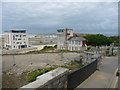
3
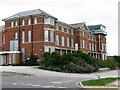
Fortuneswell - RNAS Portland Helicopter Control Tower
This used to be the helecoptor control tower for RNAS Portland, it is currently boarded up awaiting its future.
Image: © Chris Talbot
Taken: 19 Jun 2011
0.03 miles
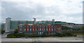
4
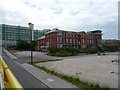
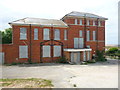
The Old Admin block
This was the administration block for the old Royal Naval Air Station. It housed the Captain's office, Met section, air ops and ATC. The Visual Control Position is the glass structure at the far end with the radar room below
Image: © Simon Palmer
Taken: 29 Aug 2010
0.05 miles
5
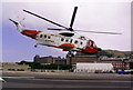
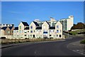
Coastguard helicopter base, Osprey Quay, Portland
Coastguard Rescue Helicopter "Whiskey Bravo" gets airborne from its base at Osprey Quay. In the background is the hangar in which it was housed (until the new one opened - see other pictures in this section). Also visible are the old Royal Navy quarters, and Portland Castle is visible on the left.
Image: © Stephen Williams
Taken: 18 Jul 2003
0.06 miles
6
Fortuneswell - RNAS Portland Helicopter Control Tower
This used to be the helecoptor control tower for RNAS Portland, it is currently boarded up awaiting its future.
Image: © Chris Talbot
Taken: 19 Jun 2011
0.06 miles
7
Fortuneswell - RNAS Portland Helicopter Control Tower
This used to be the helecoptor control tower for RNAS Portland, it is currently boarded up awaiting its future.
Image: © Chris Talbot
Taken: 19 Jun 2011
0.06 miles
8
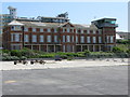
The old administration building, RNAS Portland
This building housed various departments; ATC, Met office, Air Ops Room, Captains Office etc when the air station was operational
Image: © Simon Palmer
Taken: 7 Jun 2008
0.07 miles
9
Coastguard Helicopter Landing, Osprey Quay
Image: © Ivan Hall
Taken: 11 Apr 2010
0.07 miles
10
Fortuneswell - RNAS Portland Helicopter Control Tower
This used to be the helicopter control tower for RNAS Portland, it is currently boarded up awaiting its future.
There is still a painted sign on the building which says shelter so I suspect that there is an underground air raid shelter on the site.
Image: © Chris Talbot
Taken: 19 Jun 2011
0.08 miles