IMAGES TAKEN NEAR TO
Higher Lane, PORTLAND, DT5 1AT
Introduction
This page details the photographs taken nearby to Higher Lane, DT5 1AT by members of the Geograph project.
The Geograph project started in 2005 with the aim of publishing, organising and preserving representative images for every square kilometre of Great Britain, Ireland and the Isle of Man.

There are currently over 7.5m images from over14,400 individuals and you can help contribute to the project by visiting https://www.geograph.org.uk
Image Map
Images are licensed for reuse under creativecommons.org/licenses/by-sa/2.0
Notes
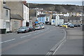
- Clicking on the map will re-center to the selected point.
- The higher the marker number, the further away the image location is from the centre of the postcode.
Image Listing (283 Images Found)
Images are licensed for reuse under creativecommons.org/licenses/by-sa/2.0
Image
Details
Distance
1
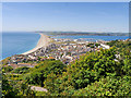
Fortuneswell
A view of Fortuneswell and the northern part of Portland Island from the top of the hill, near the War Memorial at Yeates Road.
Image: © David Dixon
Taken: 17 Jun 2017
0.01 miles
2
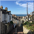
Descending Higher Lane, Chiswell, Portland
Higher Lane drops steeply from Castle Road to Chiswell High Street. The impressive dead flower spikes are of one of the giant lobelias, native only to the East African mountains that include Kilimanjaro.
Portland is extraordinary.
Image: © Robin Stott
Taken: 16 Sep 2017
0.01 miles
3
Junction of Castle Road with Verne Common Road, Fortuneswell
Image: © Chris Gunns
Taken: 25 May 2009
0.02 miles
4
Through the houses to Chesil Beach
View across gardens in Fortuneswell towards Chesil Beach.
Image: © Gareth James
Taken: 10 Jun 2017
0.02 miles
5
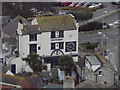
Britannia, Fortuneswell
Large pub on the main street in Fortuneswell, Portland.
Image: © Colin Smith
Taken: 14 Jan 2012
0.03 miles
6
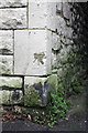
Benchmark on Osborne Hall, Queen's Road
Ordnance Survey cut mark benchmark described on the Bench Mark Database at http://www.bench-marks.org.uk/bm40266
Image: © Roger Templeman
Taken: 21 Nov 2011
0.03 miles
7
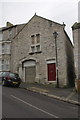
Osborne Hall, Queen's Road
1889 is cut on the stone at the centre of the arch above the gate. On the right corner of this former church is an OS benchmark Image
Image: © Roger Templeman
Taken: 21 Nov 2011
0.03 miles
8

Chesil Beach and Portland Harbour
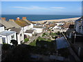
The near-standard view -- Chiswell, Fortuneswell, Chesil Beach, Portland Harbour and, in the distance, Weymouth -- from the course of the Merchants Tramroad above New Road near Priory Corner.
Image: © A-M-Jervis
Taken: 6 Jul 2007
0.03 miles
9
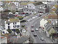
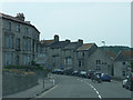
Castle Road, Fortuneswell
Main road running through Portland's largest village. The Britannia pub is prominent on the road bend.
http://en.wikipedia.org/wiki/Isle_of_Portland
Image: © Colin Smith
Taken: 14 Jan 2012
0.04 miles