IMAGES TAKEN NEAR TO
Church Knap, WEYMOUTH, DT4 9XZ
Introduction
This page details the photographs taken nearby to Church Knap, DT4 9XZ by members of the Geograph project.
The Geograph project started in 2005 with the aim of publishing, organising and preserving representative images for every square kilometre of Great Britain, Ireland and the Isle of Man.

There are currently over 7.5m images from over14,400 individuals and you can help contribute to the project by visiting https://www.geograph.org.uk
Image Map
Images are licensed for reuse under creativecommons.org/licenses/by-sa/2.0
Notes
- Clicking on the map will re-center to the selected point.
- The higher the marker number, the further away the image location is from the centre of the postcode.
Image Listing (76 Images Found)
Images are licensed for reuse under creativecommons.org/licenses/by-sa/2.0
Image
Details
Distance
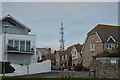
1
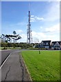
Wyke Regis, mast
Seen from Church Knap.
Image: © Mike Faherty
Taken: 23 Oct 2013
0.03 miles
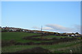
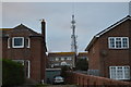
5
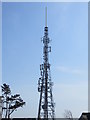
Communications and TV Mast at Wyke Regis
Viewed from the west.
Image: © Peter Wood
Taken: 29 Mar 2014
0.04 miles
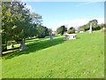
6

Wyke Regis
Top of hill has a covered reservoir. Highest point seems on road or high ground in the new estate near the reservoir compound.
Name: Wyke Regis
Hill number: 18332
Height: 69m / 226ft
Parent (Ma/M): 2896 Lewesdon Hill
Section: 41: South Central England
County/UA: Dorset (CoU)
Class: Tump (0-99m)
Grid ref: SY663779 (est)
Drop: 56m
Col: 13m SY651786
Image: © Rude Health
Taken: 27 Mar 2015
0.07 miles
7
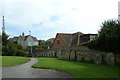
Wyke Regis, disused churchyard
Smaller gravestones have been lined up along the walls.
Image: © Mike Faherty
Taken: 23 Oct 2013
0.07 miles
8
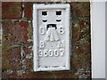
Ordnance Survey Flush Bracket G5007
This can be found on the wall of a house in Portland Road, Wyke Regis
For more detail see : http://www.bench-marks.org.uk/bm14706
Image: © Peter Wood
Taken: 29 Mar 2014
0.09 miles