IMAGES TAKEN NEAR TO
Hawthorn Close, WEYMOUTH, DT4 9UG
Introduction
This page details the photographs taken nearby to Hawthorn Close, DT4 9UG by members of the Geograph project.
The Geograph project started in 2005 with the aim of publishing, organising and preserving representative images for every square kilometre of Great Britain, Ireland and the Isle of Man.

There are currently over 7.5m images from over14,400 individuals and you can help contribute to the project by visiting https://www.geograph.org.uk
Image Map
Images are licensed for reuse under creativecommons.org/licenses/by-sa/2.0
Notes
- Clicking on the map will re-center to the selected point.
- The higher the marker number, the further away the image location is from the centre of the postcode.
Image Listing (27 Images Found)
Images are licensed for reuse under creativecommons.org/licenses/by-sa/2.0
Image
Details
Distance
8

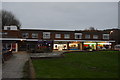
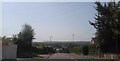
Weymouth: boundary stone in Southill parade
This boundary stone stands within the relatively modern shopping parade in the suburb of Southill (see Image) so is presumably not in its original location.
Another similar one stands on Chickerell Road in what is more likely to be an original setting: Image
Meanwhile, two ladies await their lunch outside the fish and chip shop.
Image: © Chris Downer
Taken: 14 Jan 2017
0.15 miles