IMAGES TAKEN NEAR TO
Beaulieu, WEYMOUTH, DT4 9SQ
Introduction
This page details the photographs taken nearby to Beaulieu, DT4 9SQ by members of the Geograph project.
The Geograph project started in 2005 with the aim of publishing, organising and preserving representative images for every square kilometre of Great Britain, Ireland and the Isle of Man.

There are currently over 7.5m images from over14,400 individuals and you can help contribute to the project by visiting https://www.geograph.org.uk
Image Map (Loading...)


Getting Data...Please wait
Leaflet Map data © OpenStreetMap
Images are licensed for reuse under creativecommons.org/licenses/by-sa/2.0
Notes
- Clicking on the map will re-center to the selected point.
- The higher the marker number, the further away the image location is from the centre of the postcode.
Image Listing (27 Images Found)
Images are licensed for reuse under creativecommons.org/licenses/by-sa/2.0
Image
Details
Distance
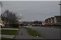
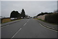
1
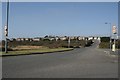
Southill, Weymouth, Dorset
Looking west from the A354 across the large housing estate at Southill.
Image: © Brendan and Ruth McCartney
Taken: Unknown
0.03 miles
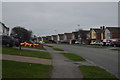
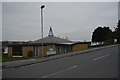
4
Southill, Weymouth
Houses on Field Barn Drive
Image: © Nigel Mykura
Taken: 2 Aug 2008
0.11 miles
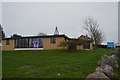
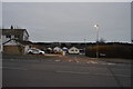
6
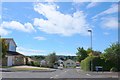
Southill Weymouth
View south down Farm Close with Wyke in the distance
Image: © Nigel Mykura
Taken: 2 Aug 2008
0.12 miles