IMAGES TAKEN NEAR TO
Wyke Road, WEYMOUTH, DT4 9QP
Introduction
This page details the photographs taken nearby to Wyke Road, DT4 9QP by members of the Geograph project.
The Geograph project started in 2005 with the aim of publishing, organising and preserving representative images for every square kilometre of Great Britain, Ireland and the Isle of Man.

There are currently over 7.5m images from over14,400 individuals and you can help contribute to the project by visiting https://www.geograph.org.uk
Image Map
Images are licensed for reuse under creativecommons.org/licenses/by-sa/2.0
Notes
- Clicking on the map will re-center to the selected point.
- The higher the marker number, the further away the image location is from the centre of the postcode.
Image Listing (16 Images Found)
Images are licensed for reuse under creativecommons.org/licenses/by-sa/2.0
Image
Details
Distance
1
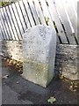
Old Boundary Marker by the B3153, Wyke Road, Weymouth
Parish Boundary Marker by the UC road, in parish of Weymouth (Weymouth and Portland District), Wyke Road, against wall of No 116, North side of road.
Inscription reads:-
BOR(OUGH)
OF
WEYMOUTH
AND
MELCOMBE
REGIS
1895
Surveyed
Milestone Society National ID: DO_WM08pb
Image: © Milestone Society
Taken: Unknown
0.07 miles
2
Curtis Fields, Weymouth
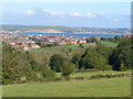
A haven of green fields (but under threat of development) within Weymouth's suburbs. From this point at the southern edge of the square, there is a dramatic view over the town and Weymouth Bay to the East Dorset coast beyond. View looking north-east.
Image: © Derek Harper
Taken: 19 Sep 2005
0.18 miles
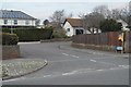
4
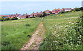
Footpath to Markham Avenue
Surrounded by housing is a large area of old fields that has avoided being built over. It doesn't appear to be a park as such, just grassland and trees.
Image: © Des Blenkinsopp
Taken: 31 May 2019
0.19 miles
7
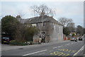
South Belfield
Grade II listed. https://historicengland.org.uk/listing/the-list/list-entry/1135198
Image: © N Chadwick
Taken: 1 Jan 2019
0.21 miles