IMAGES TAKEN NEAR TO
Wyke Road, WEYMOUTH, DT4 9QJ
Introduction
This page details the photographs taken nearby to Wyke Road, DT4 9QJ by members of the Geograph project.
The Geograph project started in 2005 with the aim of publishing, organising and preserving representative images for every square kilometre of Great Britain, Ireland and the Isle of Man.

There are currently over 7.5m images from over14,400 individuals and you can help contribute to the project by visiting https://www.geograph.org.uk
Image Map
Images are licensed for reuse under creativecommons.org/licenses/by-sa/2.0
Notes
- Clicking on the map will re-center to the selected point.
- The higher the marker number, the further away the image location is from the centre of the postcode.
Image Listing (20 Images Found)
Images are licensed for reuse under creativecommons.org/licenses/by-sa/2.0
Image
Details
Distance
2
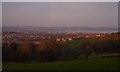
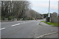
Curtis Fields, Weymouth
A haven of green fields (but under threat of development) within Weymouth's suburbs. From this point at the southern edge of the square, there is a dramatic view over the town and Weymouth Bay to the East Dorset coast beyond. View looking north-east.
Image: © Derek Harper
Taken: 19 Sep 2005
0.16 miles
3
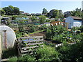
Faircross allotments
Set on Everest Road these allotments are one of nine sites in Weymouth and are self managed.
Image: © Neil Owen
Taken: 26 May 2023
0.17 miles
5
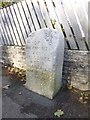
Old Boundary Marker by the B3153, Wyke Road, Weymouth
Parish Boundary Marker by the UC road, in parish of Weymouth (Weymouth and Portland District), Wyke Road, against wall of No 116, North side of road.
Inscription reads:-
BOR(OUGH)
OF
WEYMOUTH
AND
MELCOMBE
REGIS
1895
Surveyed
Milestone Society National ID: DO_WM08pb
Image: © Milestone Society
Taken: Unknown
0.22 miles
7
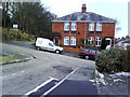
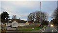
Semi on Tennyson Road from Pretoria Terrace
Image: © Roger Templeman
Taken: 23 Dec 2010
0.22 miles
8
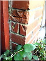
Benchmark on #4 Tennyson Road
Ordnance Survey cut mark benchmark described on the Bench Mark Database at http://www.bench-marks.org.uk/bm36365
Image: © Roger Templeman
Taken: 23 Dec 2010
0.22 miles