IMAGES TAKEN NEAR TO
Rylands Lane, WEYMOUTH, DT4 9QA
Introduction
This page details the photographs taken nearby to Rylands Lane, DT4 9QA by members of the Geograph project.
The Geograph project started in 2005 with the aim of publishing, organising and preserving representative images for every square kilometre of Great Britain, Ireland and the Isle of Man.

There are currently over 7.5m images from over14,400 individuals and you can help contribute to the project by visiting https://www.geograph.org.uk
Image Map
Images are licensed for reuse under creativecommons.org/licenses/by-sa/2.0
Notes
- Clicking on the map will re-center to the selected point.
- The higher the marker number, the further away the image location is from the centre of the postcode.
Image Listing (23 Images Found)
Images are licensed for reuse under creativecommons.org/licenses/by-sa/2.0
Image
Details
Distance
2
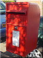
Weymouth: postbox № DT4 50, Ryland?s Lane
This postbox is of a prototype new design and is made of plastic coated steel, so there is no paintwork to deteriorate. It is, apparently, the first (or, at least, only known) example of this style of box.
Although it looks unremarkable at first glance, it is slightly wider than a standard box and the cipher is quite different: the E II R is positioned to the right of the crown, rather than the crown being central above the II in a standard box (see for random example Image).
Image: © Chris Downer
Taken: 7 Sep 2013
0.11 miles

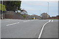
7
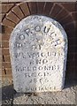
Old Boundary Marker by the A354, Buxton Road, Weymouth Parish
Parish Boundary Marker by the A354, in parish of Weymouth (Weymouth And Portland District), Buxton Road, opposite junction with Rylands Lane partially inset into wall, North side of road.
Inscription reads:- : BOROUGH / OF / WEYMOUTH / AND / MELCOMBE / REGI / 18(?)5 / T WILLIAMS E(SQ) :
Surveyed
Milestone Society National ID: DO_WM07pb
Image: © Milestone Society
Taken: Unknown
0.13 miles