IMAGES TAKEN NEAR TO
Westhill Road, WEYMOUTH, DT4 9NF
Introduction
This page details the photographs taken nearby to Westhill Road, DT4 9NF by members of the Geograph project.
The Geograph project started in 2005 with the aim of publishing, organising and preserving representative images for every square kilometre of Great Britain, Ireland and the Isle of Man.

There are currently over 7.5m images from over14,400 individuals and you can help contribute to the project by visiting https://www.geograph.org.uk
Image Map
Images are licensed for reuse under creativecommons.org/licenses/by-sa/2.0
Notes
- Clicking on the map will re-center to the selected point.
- The higher the marker number, the further away the image location is from the centre of the postcode.
Image Listing (60 Images Found)
Images are licensed for reuse under creativecommons.org/licenses/by-sa/2.0
Image
Details
Distance
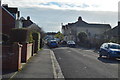
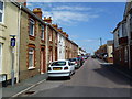
2
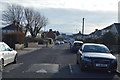
Former shops in Wyke Regis High Street
Now the road is almost purely residential with all the shops in the Portland Road, 200m to the East.
Image: © Andy Potter
Taken: 23 Jul 2011
0.10 miles
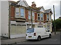
6
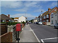
Wyke Regis High Street
Unusually for a high street, the only remaining signs of commercial activity are a hair salon and a pub.
Image: © Mike Faherty
Taken: 9 Jul 2011
0.11 miles
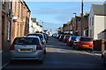
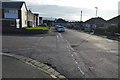
10
Wyke Regis, junior school
Wyke Regis CoE Junior School, on High Street. http://wykeregisjun.co.uk/
Image: © Mike Faherty
Taken: 9 Jul 2011
0.13 miles