IMAGES TAKEN NEAR TO
Clearmount Road, WEYMOUTH, DT4 9LS
Introduction
This page details the photographs taken nearby to Clearmount Road, DT4 9LS by members of the Geograph project.
The Geograph project started in 2005 with the aim of publishing, organising and preserving representative images for every square kilometre of Great Britain, Ireland and the Isle of Man.

There are currently over 7.5m images from over14,400 individuals and you can help contribute to the project by visiting https://www.geograph.org.uk
Image Map
Images are licensed for reuse under creativecommons.org/licenses/by-sa/2.0
Notes
- Clicking on the map will re-center to the selected point.
- The higher the marker number, the further away the image location is from the centre of the postcode.
Image Listing (91 Images Found)
Images are licensed for reuse under creativecommons.org/licenses/by-sa/2.0
Image
Details
Distance
1
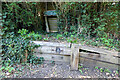
Sandsfoot Castle Halt
The very short halt was opened in 1932 to counter increasing competition from buses. It was served by railmotors and lasted for 20 years. Beside the Rodwell Trail which follows the old rail line to Portland. It is marked by an old Southern Region 'totem' station sign.
Image: © John Lucas
Taken: 14 Oct 2020
0.08 miles
2

Sandsfoot Castle Halt
Site of a former station on the Weymouth & Portland Railway, closed in 1965. The trackbed is now a path and cycle trail. https://www.dorsetforyou.gov.uk/article/411203/The-Rodwell-Trail
Image: © Mike Faherty
Taken: 30 Jul 2016
0.09 miles
3
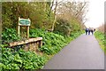
Remains of Sandsfoot Castle Halt
This small station halt was on the Weymouth and Portland Railway line. The line had been in use since 1864, but this halt opened only in 1932, as an attempt to compete with the local buses. The line closed to passengers in 1952 (just 20 years after this halt opened), although freight trains ran until 1965. The track bed is now a public footpath and cycle way.
Image: © mike smith
Taken: 17 Mar 2012
0.09 miles
5

Coloured housefronts in Old Castle Road
Image: © David Martin
Taken: 1 May 2017
0.10 miles
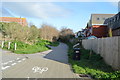
8

Sandsfoot, park homes
Overlooking Castle Cove.
Image: © Mike Faherty
Taken: 30 Jul 2016
0.11 miles
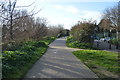
10
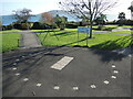
A year in Sandsfoot Gardens
The gardens were renovated in 2006 with some intriguing landscaping. Set into the tarmac are some tiles, marking the months of the calendar in varying sizes; around them are numerals, in a semi-circular arc but with some duplicated across the gap. Is it some sort of sundial?
Image: © Neil Owen
Taken: 18 Nov 2022
0.11 miles