IMAGES TAKEN NEAR TO
Clearmount Road, WEYMOUTH, DT4 9LD
Introduction
This page details the photographs taken nearby to Clearmount Road, DT4 9LD by members of the Geograph project.
The Geograph project started in 2005 with the aim of publishing, organising and preserving representative images for every square kilometre of Great Britain, Ireland and the Isle of Man.

There are currently over 7.5m images from over14,400 individuals and you can help contribute to the project by visiting https://www.geograph.org.uk
Image Map (74 Images)


Getting Data...Please wait
Leaflet Map data © OpenStreetMap
Images are licensed for reuse under creativecommons.org/licenses/by-sa/2.0
Notes
- Clicking on the map will re-center to the selected point.
- The higher the marker number, the further away the image location is from the centre of the postcode.
Image Listing (74 Images Found)
Images are licensed for reuse under creativecommons.org/licenses/by-sa/2.0
Image
Details
Distance
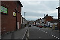
4

Weymouth: Buxton Road Post Office
When the Post Office Ltd announced the result of its Dorset closure plan consultation, this was one of two branches that were given further consideration before making a final decision. Nevertheless the final decision in respect of both branches under this 'further consideration' was that they close also, so this one will go in the new year.
Image: © Chris Downer
Taken: 27 Dec 2008
0.05 miles
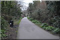
5

Rodwell Trail
The trackbed of the Weymouth & Portland Railway, closed 1965; now a path and cycle trail: https://www.dorsetforyou.gov.uk/article/411203/The-Rodwell-Trail
Image: © Mike Faherty
Taken: 30 Jul 2016
0.06 miles
6
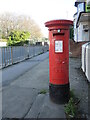
Letterbox on Buxton Road
A George V letterbox by Carron, standing outside what appears to have been a shop.
Image: © Neil Owen
Taken: 18 Nov 2022
0.06 miles

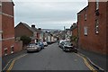
8
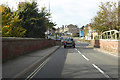
A354 Buxton Road
Looking across a bridge over the former railway to Portland. Now a foot and cycle way - the Strawberry Line.
Image: © Robin Webster
Taken: 3 Nov 2018
0.07 miles

10
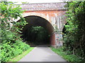
Looking North with Bridge Over the A354
Now part of the Rodwell Trail, also known as NCN 26.
Image: © William Fairbrother
Taken: 21 Aug 2012
0.07 miles