IMAGES TAKEN NEAR TO
Camp Road, WEYMOUTH, DT4 9HG
Introduction
This page details the photographs taken nearby to Camp Road, DT4 9HG by members of the Geograph project.
The Geograph project started in 2005 with the aim of publishing, organising and preserving representative images for every square kilometre of Great Britain, Ireland and the Isle of Man.

There are currently over 7.5m images from over14,400 individuals and you can help contribute to the project by visiting https://www.geograph.org.uk
Image Map
Images are licensed for reuse under creativecommons.org/licenses/by-sa/2.0
Notes
- Clicking on the map will re-center to the selected point.
- The higher the marker number, the further away the image location is from the centre of the postcode.
Image Listing (57 Images Found)
Images are licensed for reuse under creativecommons.org/licenses/by-sa/2.0
Image
Details
Distance
1
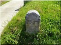
Old Boundary Marker by Camp Road, Weymouth
Parish Boundary Marker by the UC road, in parish of Weymouth (Weymouth and Portland District), Camp Road, opposite junction with Mandeville Road, on embankment, Southeast side of road.
Inscription reads:-
BOROUGH
OF
WEYMOUTH
AND
MELCOMBE
REGIS
Carved bench mark and rivet on top.
Surveyed
Milestone Society National ID: DO_WM03pb
Image: © Milestone Society
Taken: Unknown
0.08 miles
2
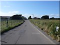
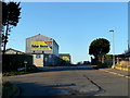
Wyke Regis
View NNW along the approach road to the country goods superstore
Image: © Nigel Mykura
Taken: 23 Jun 2008
0.14 miles
3
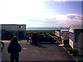
View of the English Channel from Pebble Bank Caravan Park
This view was taken from Pebble Bank Caravan Park looking south-southeast out towards the English Channel. The building on the left is the caravan site's own bar, which has a fantastic view of the sea and Portland to the south-east (and most importantly, good beer!)
Image: © Robert Lamb
Taken: 16 Oct 2009
0.14 miles
4
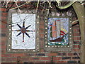
Wall Murals
Two decorative ceramic wall murals on a house in Westhill Road, Wyke Regis.
Image: © Lorraine and Keith Bowdler
Taken: 17 Feb 2010
0.15 miles
5
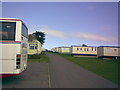
View uphill of the caravan site
Pebble Bank Caravan Site is based around a very steep hill leading from the car park right up to the northern extremity of the park. The positioning of the caravans here adds a rather nice touch to the scenery and really complements the slope! View taken looking northwest, parallel to Camp Road.
Image: © Robert Lamb
Taken: 16 Oct 2009
0.17 miles
6
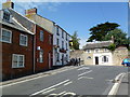
Wyke Regis, Albert Inn
At the corner of High Street and Chamberlaine Road; internally, back bar, with drinking and eating areas left, front, right; darts, pool and a patio. Cask ale on offer at my visit: Greene King Abbot Ale. For some customer comments, see http://www.beerintheevening.com/pubs/s/31/31080/Albert_Inn/Wyke_Regis
Image: © Mike Faherty
Taken: 9 Jul 2011
0.18 miles
7
Value House, Weymouth
A veritable "Aladdin's Cave". Unpretentious from the outside.
Image: © Jonathan Billinger
Taken: 4 Jan 2010
0.18 miles
8
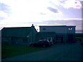
The bar at Pebble Bank Caravan Park
Pebble Bank Caravan Park has its own bar next to the site owner's house, both of which have excellent views of the English Channel and the Isle of Portland, just out of shot to the left in the image. View taken looking east-southeast out to sea.
Image: © Robert Lamb
Taken: 16 Oct 2009
0.19 miles
9
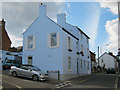
Formerly the Masons Arms
Now a private house the blue buildings comprise a single property. The pub occupied the three-storey structure and possibly the adjoining two-storey buildings. The unusual colour makes the building stand out and it can be seen with the naked eye from the Newgrounds viewpoint on Portland some 5km away.
Image: © Andy Potter
Taken: 23 Jul 2011
0.20 miles
10
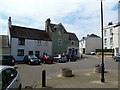
Old Wyke Village Stores
In The Square.
Image: © Mike Faherty
Taken: 9 Jul 2011
0.21 miles