IMAGES TAKEN NEAR TO
Cambridge Road, WEYMOUTH, DT4 9GH
Introduction
This page details the photographs taken nearby to Cambridge Road, DT4 9GH by members of the Geograph project.
The Geograph project started in 2005 with the aim of publishing, organising and preserving representative images for every square kilometre of Great Britain, Ireland and the Isle of Man.

There are currently over 7.5m images from over14,400 individuals and you can help contribute to the project by visiting https://www.geograph.org.uk
Image Map
Images are licensed for reuse under creativecommons.org/licenses/by-sa/2.0
Notes
- Clicking on the map will re-center to the selected point.
- The higher the marker number, the further away the image location is from the centre of the postcode.
Image Listing (19 Images Found)
Images are licensed for reuse under creativecommons.org/licenses/by-sa/2.0
Image
Details
Distance
2
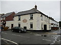
The Alex, Charlestown, Chickerell
The Alex, 408 Chickerell Road, Charlestown, closed 11 June. Formerly the Alexandra Inn, it had been struggling and making a loss overall for the last few years, despite support from locals. Being unsuitable for food trade it was considered impossible to sell as a going concern and so is being returned to its original state as three individual houses.
Image: © John Stephen
Taken: 11 Jul 2017
0.15 miles
3
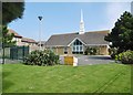
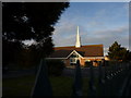
Charlestown, church
Church of Jesus Christ of Latter-Day Saints, on Chickerell Road: https://www.facebook.com/pg/Church-of-Jesus-Christ-of-Latter-Day-Saints-Weymouth-Branch-186201288173459/about/?ref=page_internal
Image: © Mike Faherty
Taken: 14 Apr 2018
0.16 miles
5
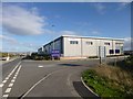
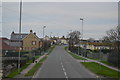
Charlestown, Link Park
Business Park off Hampshire Road.
Image: © Mike Faherty
Taken: 23 Oct 2013
0.17 miles
6
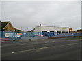
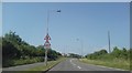
Redevelopment of Charlestown Service Station, Chickerell Road
Was an MOT Service station with Camping and Caravan accessories shop which shut in 2016. Planning permission was granted to part demolish, alter and extend the existing Charlestown Garage buildings, and to change the use of the site to form a convenience retail shop, with three other smaller units, including a takeaway.
Local council objected as Budmouth college is diagonally opposite across the road and extra traffic would be considered a hazard. Note the contractor M J Church are from Marshfield, S Glos on the Wilts/Glos border, who apparently specialise in clearing and developing environmentally hazardous sites. Two fuel tanks have been unearthed for disposal.
Image: © John Stephen
Taken: 10 Jan 2017
0.18 miles
7
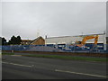
Redevelopment of Charlestown Service Station, Chickerell Road
Was an MOT Service station with Camping and Caravan accessories shop which shut in 2016. Planning permission was granted to part demolish, alter and extend the existing Charlestown Garage buildings, and to change the use of the site to form a convenience retail shop, with three other smaller units, including a takeaway.
Local council objected as Budmouth college is diagonally opposite across the road and extra traffic would be considered a hazard. Note the contractor M J Church are from Marshfield, S Glos on the Wilts/Glos border, who apparently specialise in clearing and developing environmentally hazardous sites.
Image: © John Stephen
Taken: 10 Jan 2017
0.18 miles
8
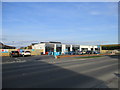
Charlestown Co-op
Image: © John Stephen
Taken: 20 Mar 2018
0.18 miles
9
The Church of Jesus Christ of Later-day Saints
Image: © Ivan Hall
Taken: 15 May 2011
0.19 miles
10
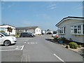
Charlestown, park homes
Cerne Villa Park, off Chickerell Road: https://www.wyldecrestparks.co.uk/property_location/cerne-villa-park/
Image: © Mike Faherty
Taken: 14 Apr 2018
0.20 miles