IMAGES TAKEN NEAR TO
The Maltings, WEYMOUTH, DT4 8UT
Introduction
This page details the photographs taken nearby to The Maltings, DT4 8UT by members of the Geograph project.
The Geograph project started in 2005 with the aim of publishing, organising and preserving representative images for every square kilometre of Great Britain, Ireland and the Isle of Man.

There are currently over 7.5m images from over14,400 individuals and you can help contribute to the project by visiting https://www.geograph.org.uk
Image Map (Loading...)


Getting Data...Please wait
Leaflet Map data © OpenStreetMap
Images are licensed for reuse under creativecommons.org/licenses/by-sa/2.0
Notes
- Clicking on the map will re-center to the selected point.
- The higher the marker number, the further away the image location is from the centre of the postcode.
Image Listing (689 Images Found)
Images are licensed for reuse under creativecommons.org/licenses/by-sa/2.0
Image
Details
Distance
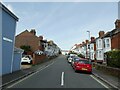
1
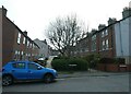
Looking across Spring Road into Mount Street
(where it meets its boundary with Rodwell Avenue)
Image: © Basher Eyre
Taken: 2 May 2023
0.03 miles
2
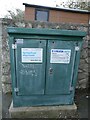
Topical message spotted in Spring Road
Raw sewage has been a huge problem in UK rivers and estuaries in the 2020's https://theriverstrust.org/key-issues/sewage-in-rivers
Image: © Basher Eyre
Taken: 2 May 2023
0.04 miles
3
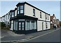
Former shop at the junction of Spring and Newberry Roads
Image: © Basher Eyre
Taken: 2 May 2023
0.04 miles
4
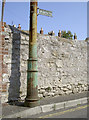
Losing the message
A footpath sign (presumably!) in Marlow Road has been shortened somewhat. The lamppost is of a more substantial constitution and has survived many years, although it no longer has a light.
Image: © Neil Owen
Taken: 3 Sep 2014
0.04 miles
5
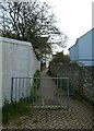
Path from Spring Road to St Leonard's Road
Image: © Basher Eyre
Taken: 2 May 2023
0.04 miles
6
Looking from Spring Road into Newberry Road
Image: © Basher Eyre
Taken: 2 May 2023
0.04 miles
7
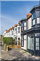
Newberry Road
Looking along the east side of Newberry Road from its junction with Rodwell Avenue/Spring Road. The houses here are first shown on the 1929 25" map, although the other side of the road is shown as partly developed on the 1866 edition, and fully developed (along with the taller terrace in the background in this photo) on the 1902 edition. On all these maps the road is shown as Dorset Place (a name initially applied just to the terrace on the west side, but later to the road itself), the current name not appearing until the 1965 1:1250 map.
Image: © Ian Capper
Taken: 1 Feb 2024
0.04 miles
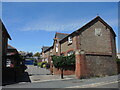
8
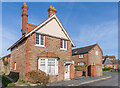
Stable Lodge
House on Spring Road (no 1), first shown on the 1929 25" map. On the right is the end of Shire Horse Mews (with a date plaque of 1902, the similar brickwork suggesting that Stable Lodge was of the same date) and in the right background is a former malthouse, all buildings connected with Devenish Brewery.
Image: © Ian Capper
Taken: 1 Feb 2024
0.05 miles
9
Shire Horse Mews
Some of the old Devenish Brewery buildings are now converted into residential use.
Image: © Neil Owen
Taken: 15 Jun 2022
0.05 miles
10
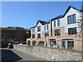
New to Weymouth
The Maltings are becoming closer to the finished product.
Image: © Neil Owen
Taken: 19 Jul 2024
0.05 miles