IMAGES TAKEN NEAR TO
Barrack Road, WEYMOUTH, DT4 8UD
Introduction
This page details the photographs taken nearby to Barrack Road, DT4 8UD by members of the Geograph project.
The Geograph project started in 2005 with the aim of publishing, organising and preserving representative images for every square kilometre of Great Britain, Ireland and the Isle of Man.

There are currently over 7.5m images from over14,400 individuals and you can help contribute to the project by visiting https://www.geograph.org.uk
Image Map (Loading...)


Getting Data...Please wait
Leaflet Map data © OpenStreetMap
Images are licensed for reuse under creativecommons.org/licenses/by-sa/2.0
Notes
- Clicking on the map will re-center to the selected point.
- The higher the marker number, the further away the image location is from the centre of the postcode.
Image Listing (1404 Images Found)
Images are licensed for reuse under creativecommons.org/licenses/by-sa/2.0
Image
Details
Distance
1
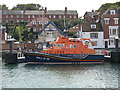
Weymouth Lifeboat
Weymouth Lifeboat Docked in the Harbour.
Image: © steve bailey
Taken: 19 Aug 2006
0.01 miles
2
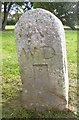
Old Boundary Marker by Barrack Road, Weymouth
Estate Boundary Marker - War Department #5, by the UC road, in parish of Weymouth (Weymouth and Portland District), Barrack Road, edge of green between pub and cafe, near car park.
Surveyed
Milestone Society National ID: DO_WDNOT05em
Image: © Mike Faherty
Taken: 12 Oct 2013
0.01 miles
3
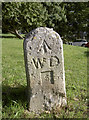
Military boundaries
An old marker stone, inscribed with 'WD' for War Department, along the road to Nothe Fort. The military have had a long history here in Weymouth - an important sea port for many years - and hence there are several more in the headland; this is number five.
Image: © Neil Owen
Taken: 28 Aug 2011
0.01 miles
4
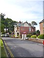
Weymouth, Nothe Tavern
Former Eldridge Pope pub on Barrack Road. Internally, bar right, with eating and drinking areas front and left, dining at back; terrace with harbour view. Cask ales on offer at my visit: Ringwood Best, Fortyniner, Jennings Crag Rat. For some customer comments, see http://www.beerintheevening.com/pubs/s/22/22029/Nothe_Tavern/Weymouth
Image: © Mike Faherty
Taken: 12 Oct 2013
0.02 miles
5

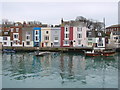
Quayside, Weymouth, Dorset
Looking across the harbour towards the south quay.
Image: © Christine Matthews
Taken: 12 Aug 2010
0.02 miles
7
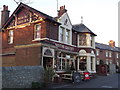
Nothe Tavern
Well established pub between the former barracks and the old fort. it offers good views over Weymouth Bay and Harbour.
http://en.wikipedia.org/wiki/Weymouth,_Dorset
Image: © Colin Smith
Taken: 15 Jan 2012
0.03 miles
9
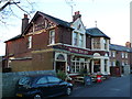
Nothe Tavern
This public house is on Barrack Rd on the Nothe which is a high headland next to Weymouth. Over the years it has had many military installations on it, mostly defensive positions such as the Napoleonic Wars Fort which was adapted in subsequent wars.
Image: © Nigel Mykura
Taken: 15 Jan 2012
0.03 miles
10
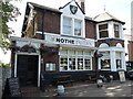
The Nothe Tavern
Situated (perhaps profitably considering the soldiers on the site) on Barrack Road and close to the old fort, this pub had to close during July, 2021, after staff were forced to self-isolate. However, the shut-down was temporary and business resumed.
Image: © Neil Owen
Taken: 16 Jul 2021
0.03 miles