IMAGES TAKEN NEAR TO
Gordon Row, WEYMOUTH, DT4 8LL
Introduction
This page details the photographs taken nearby to Gordon Row, DT4 8LL by members of the Geograph project.
The Geograph project started in 2005 with the aim of publishing, organising and preserving representative images for every square kilometre of Great Britain, Ireland and the Isle of Man.

There are currently over 7.5m images from over14,400 individuals and you can help contribute to the project by visiting https://www.geograph.org.uk
Image Map
Images are licensed for reuse under creativecommons.org/licenses/by-sa/2.0
Notes
- Clicking on the map will re-center to the selected point.
- The higher the marker number, the further away the image location is from the centre of the postcode.
Image Listing (1032 Images Found)
Images are licensed for reuse under creativecommons.org/licenses/by-sa/2.0
Image
Details
Distance
1
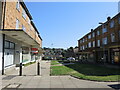
Gordon Row shops
Part of Weymouth's post-war development, with a short row of shops facing across a small green. At the moment the economic climate looks rather cool as some shops are unocupied.
Image: © Neil Owen
Taken: 19 Jul 2024
0.00 miles
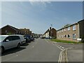
2
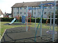
Play area on Franchise Street
A modern set of equipment for the young ones. The open space was originally a very crowded Victorian neighbourhood, but was badly damaged in the war. Weymouth was a prime target for the Luftwaffe and there were many raids, the one on 17th November, 1940, causing a clearance. Post-war, the area had two separate pubs at different times, but both are now gone.
Image: © Neil Owen
Taken: 18 Sep 2020
0.04 miles
3
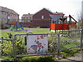
Chapelhay Play Area
This little patch of ground was once part of the older housing in Weymouth but suffered a great deal of damage during the bombings of World War II. Much was cleared and new blocks were built, but a community effort has achieved this play area. A strong theme of Nature is emphasised by the paintings attached to the fencing.
Image: © Neil Owen
Taken: 8 Apr 2015
0.05 miles
4
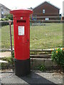
Georgian postbox on Prospect Place
This box was probably moved here after the area was badly damaged in the bombings of WWII. It's likely it would not have survived had it been here in 1940.
Image: © Neil Owen
Taken: 18 Sep 2020
0.05 miles
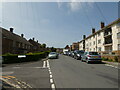
5
Looking west-southwest in Franchise Street
Image: © Basher Eyre
Taken: 2 May 2023
0.05 miles
6
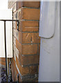
Benchmark by street furniture
A cutmark, as listed in the Benchmark Database: http://www.bench-marks.org.uk/bm61543 , on the corner of a house at the junction of St Leonard's Road and Maycroft Road. The metal post support a no entry sign. See Image
Image: © Neil Owen
Taken: 3 Sep 2014
0.05 miles
8
Junction of Oakley Place and Franchise Street
Image: © Basher Eyre
Taken: 2 May 2023
0.06 miles
9
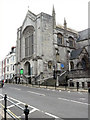
Weymouth - Holy Trinity Church
Holy Trinity Church was built between 1834-6. It was designed by Philip Wyatt and was extended by local architect G R Crickmay in 1886.
Image: © Chris Talbot
Taken: 4 Oct 2008
0.06 miles
10
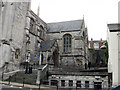
Weymouth - Holy Trinity Church
Holy Trinity Church was built between 1834-6. It was designed by Philip Wyatt and was extended by local architect G R Crickmay in 1886.
Image: © Chris Talbot
Taken: 4 Oct 2008
0.06 miles