IMAGES TAKEN NEAR TO
Orion Road, WEYMOUTH, DT4 8LG
Introduction
This page details the photographs taken nearby to Orion Road, DT4 8LG by members of the Geograph project.
The Geograph project started in 2005 with the aim of publishing, organising and preserving representative images for every square kilometre of Great Britain, Ireland and the Isle of Man.

There are currently over 7.5m images from over14,400 individuals and you can help contribute to the project by visiting https://www.geograph.org.uk
Image Map
Images are licensed for reuse under creativecommons.org/licenses/by-sa/2.0
Notes
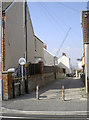
- Clicking on the map will re-center to the selected point.
- The higher the marker number, the further away the image location is from the centre of the postcode.
Image Listing (622 Images Found)
Images are licensed for reuse under creativecommons.org/licenses/by-sa/2.0
Image
Details
Distance
1
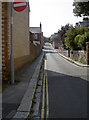
St Leonard's Road
Looking west towards Rodwell Road, with the narrowness eliciting the one-way restriction. See Image] for a look at the corner here for a benchmark.
Image: © Neil Owen
Taken: 3 Sep 2014
0.03 miles
2
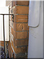
Benchmark by street furniture
A cutmark, as listed in the Benchmark Database: http://www.bench-marks.org.uk/bm61543 , on the corner of a house at the junction of St Leonard's Road and Maycroft Road. The metal post support a no entry sign. See Image
Image: © Neil Owen
Taken: 3 Sep 2014
0.03 miles
3

?Edwardsville?
These large and impressive residences are one of the examples of the generosity of one Sir Henry Edwards. He was an M.P. for the area in 1867-1885, and gifted several such charitable accommodations and annual dinners for the local elderly and poor. See Image] for the entrance.
Image: © Neil Owen
Taken: 3 Sep 2014
0.05 miles
4
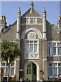
Entrance to 'Edwardsville'
These charitable trust residences were founded in 1896 as part of the work of Sir Henry Edwards. He set up a number of residences for the local elderly and poor in the town. The almshouses here are built from Portland stone in a Tudor Revival style. See Image] for a wider view.
Image: © Neil Owen
Taken: 3 Sep 2014
0.05 miles
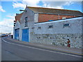
5
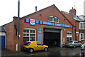
Weymouth old fire station
Weymouth old fire station, 113 Franchise Street, Weymouth, Dorset, now used by MechAniZe garage
Image: © Kevin Hale
Taken: 16 Feb 2010
0.05 miles
6
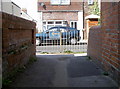
Only one way to go
Pedestrians may find this instruction a little out of place, perhaps, especially as it is a small lane leading onto Franchise Road. No cars can use it.
Image: © Neil Owen
Taken: 3 Sep 2014
0.05 miles
7
Love Lane
Almost every town has one. This is in the Rodwell district of Weymouth.
Image: © Neil Owen
Taken: 3 Sep 2014
0.07 miles
8
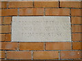
The boundary is here
An uncommon stone tablet, set into the wall of a house in Rodwell Avenue, proclaims the legally-binding limits of this lane. It appears that the said lane has brick walling on both sides, but the western side is a simple garden wall, not a house. See Image] for a better illustration.
Image: © Neil Owen
Taken: 3 Sep 2014
0.07 miles
9
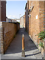
Lane to Maycroft Road
Travelling from Rodwell Avenue is a little lane. The exact width of it is not immediately obvious, but a stone tablet reassures users of the precise limits. See Image
Image: © Neil Owen
Taken: 3 Sep 2014
0.07 miles
10
Weymouth - Joinery
The old J&C Joinery.
Image: © Chris Talbot
Taken: 25 Sep 2010
0.08 miles