IMAGES TAKEN NEAR TO
Weston Road, WEYMOUTH, DT4 8JA
Introduction
This page details the photographs taken nearby to Weston Road, DT4 8JA by members of the Geograph project.
The Geograph project started in 2005 with the aim of publishing, organising and preserving representative images for every square kilometre of Great Britain, Ireland and the Isle of Man.

There are currently over 7.5m images from over14,400 individuals and you can help contribute to the project by visiting https://www.geograph.org.uk
Image Map
Images are licensed for reuse under creativecommons.org/licenses/by-sa/2.0
Notes
- Clicking on the map will re-center to the selected point.
- The higher the marker number, the further away the image location is from the centre of the postcode.
Image Listing (259 Images Found)
Images are licensed for reuse under creativecommons.org/licenses/by-sa/2.0
Image
Details
Distance
1
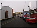
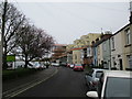
Weston Road
Looking east along Weston Road towards the Spinnaker View flats in the general direction of the harbour and North Quay. ASDA is on the left on the site of "The Rec" or "Recreation Ground" which was Weymouth FC's home for 99 years until 1986.
Image: © John Stephen
Taken: 10 Mar 2017
0.01 miles
2
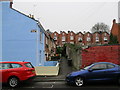
Garibaldi Row, off Weston Road
Not named after the biscuit.
Image: © John Stephen
Taken: 10 Mar 2017
0.02 miles
3
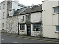
Weymouth - Chickerell Road
This seemingly unused building has some interesting glass panels.
Image: © Chris Talbot
Taken: 4 Oct 2008
0.02 miles
5
Weston Road looking towards Spinnaker View
Looking east along Weston Road towards the Spinnaker View flats in the general direction of the harbour and North Quay. ASDA is on the left on the site of "The Rec" or "Recreation Ground" which was Weymouth FC's home for 99 years until 1986.
Image: © John Stephen
Taken: 10 Mar 2017
0.02 miles
7
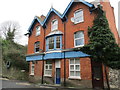
28 Chickerell Road Flats ex Railway Arch
The onetime Railway Arch Hotel converted into 6 flats in 1985, the year Devenish stopped brewing in Weymouth. The railway embankment is to the left of the building with the arch being just out of shot.
Image: © John Stephen
Taken: 10 Mar 2017
0.03 miles
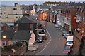
8
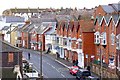
Chickerell Road
View of this busy local road from the old railway embankment and bridge, now a public footpath and cycleway. Interesting to note that the older houses have bay windows in the upper floors. This is reasonably common in Weymouth and Portland.
Image: © mike smith
Taken: 17 Mar 2012
0.03 miles

10
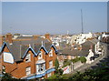
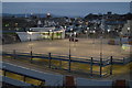
Work afar
Looking from the cycle path over Chickerell Road towards the town and harbour, a large crane marks the site of a new retirement home development.
Image: © Neil Owen
Taken: 3 Sep 2014
0.04 miles