IMAGES TAKEN NEAR TO
Longcroft Road, WEYMOUTH, DT4 0PA
Introduction
This page details the photographs taken nearby to Longcroft Road, DT4 0PA by members of the Geograph project.
The Geograph project started in 2005 with the aim of publishing, organising and preserving representative images for every square kilometre of Great Britain, Ireland and the Isle of Man.

There are currently over 7.5m images from over14,400 individuals and you can help contribute to the project by visiting https://www.geograph.org.uk
Image Map
Images are licensed for reuse under creativecommons.org/licenses/by-sa/2.0
Notes
- Clicking on the map will re-center to the selected point.
- The higher the marker number, the further away the image location is from the centre of the postcode.
Image Listing (33 Images Found)
Images are licensed for reuse under creativecommons.org/licenses/by-sa/2.0
Image
Details
Distance
1
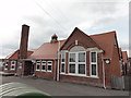
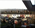
School buildings
Cromwell Road school buildings, Weymouth.
Image: © Mat Tuck
Taken: 29 May 2013
0.05 miles
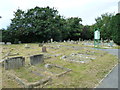
2
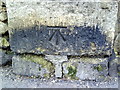
Benchmark on cemetery wall pier at junction of Cornwall Road and Longcroft Road
Ordnance Survey cut mark benchmark described on the Bench Mark Database at http://www.bench-marks.org.uk/bm36389
Image: © Roger Templeman
Taken: 23 Dec 2010
0.06 miles
3
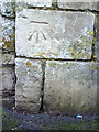
Benchmark on cemetery wall pier on Longcroft Road
Ordnance Survey cut mark benchmark described on the Bench Mark Database at http://www.bench-marks.org.uk/bm36390
Image: © Roger Templeman
Taken: 23 Dec 2010
0.12 miles
4
Rear of Emerdale Rd.
Taken from an upstairs window in Franklin Road.
Image: © Steve Barnes
Taken: 19 Jul 2004
0.12 miles
5
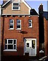
House in Franklin Road, Weymouth
One of the larger houses in this road.
Image: © Steve Barnes
Taken: Unknown
0.14 miles
6
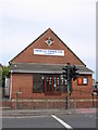
Ebenezer Evangelical Church
'The church is just over 100 years old, and historically was a Brethren fellowship. It has moved in a progressive direction and established itself as an independent evangelical fellowship, with a leadership team. It is in the heart of the urban area of Westham, with private and council housing, 0.5 miles from the town centre, esplanade, beach and harbour.'
(From the Searchchurch.co.uk website)
Image: © HelenK
Taken: 28 Aug 2007
0.15 miles
8
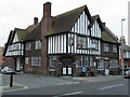
The Waverley Arms, 121 Abbotsbury Road, Westham, Weymouth
The Waverley Arms is for sale by Caldecotte Group of Stony Stratford for £295K as a development opportunity, the pub no longer being considered viable on its own. It currently has permission for 3 first floor flats with manager's accommodation. They have applied for permission to convert the whole building into 6 self-contained flats.
Note it still has a Devenish pub sign.
Image: © John Stephen
Taken: 8 Nov 2016
0.18 miles
9
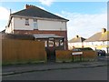
Weymouth: the Corner Kiosk on Queensland Road
This must surely be one of the smallest suburban corner shops anywhere - it occupied a small lean-to on the side of the house on the corner of Queensland and Sussex Roads.
The projecting sign indicates that it has a Payzone terminal - one of those stations where you can top up prepaid electric meter keys, pay utility bills and the like.
Image: © Chris Downer
Taken: 14 Jan 2017
0.18 miles