IMAGES TAKEN NEAR TO
Minton Place, WEYMOUTH, DT4 0EU
Introduction
This page details the photographs taken nearby to Minton Place, DT4 0EU by members of the Geograph project.
The Geograph project started in 2005 with the aim of publishing, organising and preserving representative images for every square kilometre of Great Britain, Ireland and the Isle of Man.

There are currently over 7.5m images from over14,400 individuals and you can help contribute to the project by visiting https://www.geograph.org.uk
Image Map
Images are licensed for reuse under creativecommons.org/licenses/by-sa/2.0
Notes
- Clicking on the map will re-center to the selected point.
- The higher the marker number, the further away the image location is from the centre of the postcode.
Image Listing (95 Images Found)
Images are licensed for reuse under creativecommons.org/licenses/by-sa/2.0
Image
Details
Distance
1
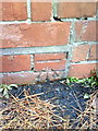
Benchmark on side of #190 Newstead Road
Ordnance Survey cut mark benchmark described on the Bench Mark Database at http://www.bench-marks.org.uk/bm36356
Image: © Roger Templeman
Taken: 23 Dec 2010
0.05 miles

3

War Memorial, Melcombe Regis Burial Ground
Image: © N Chadwick
Taken: 31 Dec 2018
0.06 miles


7
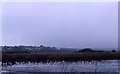
Radipole Lake
An excellent site for birds in the heart of Weymouth.
Image: © Mike Pennington
Taken: 2 Nov 1983
0.09 miles
8

Entrance Lodge, Melcombe Regis Burial Ground
Image: © N Chadwick
Taken: 31 Dec 2018
0.10 miles
9

Radipole Lake
Photo taken from Swannery Bridge (B3155).
Image: © W
Taken: 20 Nov 2017
0.10 miles