IMAGES TAKEN NEAR TO
Thornhill Crescent, WEYMOUTH, DT4 0ER
Introduction
This page details the photographs taken nearby to Thornhill Crescent, DT4 0ER by members of the Geograph project.
The Geograph project started in 2005 with the aim of publishing, organising and preserving representative images for every square kilometre of Great Britain, Ireland and the Isle of Man.

There are currently over 7.5m images from over14,400 individuals and you can help contribute to the project by visiting https://www.geograph.org.uk
Image Map
Images are licensed for reuse under creativecommons.org/licenses/by-sa/2.0
Notes
- Clicking on the map will re-center to the selected point.
- The higher the marker number, the further away the image location is from the centre of the postcode.
Image Listing (48 Images Found)
Images are licensed for reuse under creativecommons.org/licenses/by-sa/2.0
Image
Details
Distance
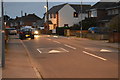
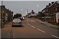
1
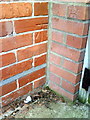
Benchmark on #44 Goldcroft Road
Ordnance Survey cut mark benchmark described on the Bench Mark Database at http://www.bench-marks.org.uk/bm36358
Image: © Roger Templeman
Taken: 23 Dec 2010
0.03 miles
7
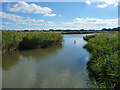
Weymouth - Radipole Lake
Taken from a small footbridge, part of Radipole Lake.
Image: © Chris Talbot
Taken: 25 Sep 2010
0.13 miles
8
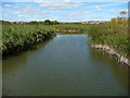
Weymouth - Radipole Lake
The view from a small footbridge that lets onto the Radipole circular footpath.
Image: © Chris Talbot
Taken: 25 Sep 2010
0.13 miles
10
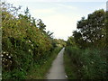
Footpath between Radipole Lake and the A354
Footpath through the reedbeds between Radipole Lake and the A354.
Image: © Stephen Williams
Taken: 27 Aug 2007
0.13 miles