IMAGES TAKEN NEAR TO
Lomond Drive, WEYMOUTH, DT4 0DH
Introduction
This page details the photographs taken nearby to Lomond Drive, DT4 0DH by members of the Geograph project.
The Geograph project started in 2005 with the aim of publishing, organising and preserving representative images for every square kilometre of Great Britain, Ireland and the Isle of Man.

There are currently over 7.5m images from over14,400 individuals and you can help contribute to the project by visiting https://www.geograph.org.uk
Image Map (Loading...)


Getting Data...Please wait
Leaflet Map data © OpenStreetMap
Images are licensed for reuse under creativecommons.org/licenses/by-sa/2.0
Notes
- Clicking on the map will re-center to the selected point.
- The higher the marker number, the further away the image location is from the centre of the postcode.
Image Listing (121 Images Found)
Images are licensed for reuse under creativecommons.org/licenses/by-sa/2.0
Image
Details
Distance
1
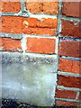
Benchmark on #9 Ashton Road
Ordnance Survey cut mark benchmark described on the Bench Mark Database at http://www.bench-marks.org.uk/bm36366
Image: © Roger Templeman
Taken: 23 Dec 2010
0.05 miles
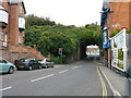
2

Weymouth - Railway Tunnel
This tunnel carries the railway line over Chickerell Road.
Image: © Chris Talbot
Taken: 4 Oct 2008
0.07 miles
4

Weymouth - Disused Pub
This disused pub stands awaiting a new use.
Image: © Chris Talbot
Taken: 4 Oct 2008
0.07 miles
5
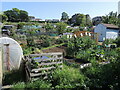
Faircross allotments
Set on Everest Road these allotments are one of nine sites in Weymouth and are self managed.
Image: © Neil Owen
Taken: 26 May 2023
0.07 miles
6
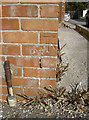
Glen Avenue benchmark
Lurking in a quiet cul-de-sac on the corner of a modern house is a cutmark. It is listed in the Benchmark Database: http://www.bench-marks.org.uk/bm60546 .
Image: © Neil Owen
Taken: 3 Sep 2014
0.07 miles
7
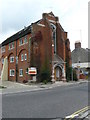
Weymouth - Converted Chapel
This chapel has been converted into flats.
Image: © Chris Talbot
Taken: 4 Oct 2008
0.08 miles
8
Benchmark on St Martin's Court, Chickerell Road
Ordnance Survey cut mark benchmark described on the Bench Mark Database at http://www.bench-marks.org.uk/bm36362
Image: © Roger Templeman
Taken: 23 Dec 2010
0.08 miles
9

Chickerell Road looking west from the railway arch
Image: © John Stephen
Taken: 10 Mar 2017
0.09 miles
10
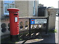
Letterbox on Lansdowne Square
A George VI version by Carron of Stirlingshire.
Image: © Neil Owen
Taken: 26 May 2023
0.09 miles