IMAGES TAKEN NEAR TO
Chickerell Road, WEYMOUTH, DT4 0BS
Introduction
This page details the photographs taken nearby to Chickerell Road, DT4 0BS by members of the Geograph project.
The Geograph project started in 2005 with the aim of publishing, organising and preserving representative images for every square kilometre of Great Britain, Ireland and the Isle of Man.

There are currently over 7.5m images from over14,400 individuals and you can help contribute to the project by visiting https://www.geograph.org.uk
Image Map
Images are licensed for reuse under creativecommons.org/licenses/by-sa/2.0
Notes
- Clicking on the map will re-center to the selected point.
- The higher the marker number, the further away the image location is from the centre of the postcode.
Image Listing (28 Images Found)
Images are licensed for reuse under creativecommons.org/licenses/by-sa/2.0
Image
Details
Distance
1
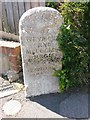
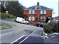
Weymouth: boundary stone on Chickerell Road
This stone stands near the corner of Markham Avenue and is inscribed: BOROUGH OF WEYMOUTH AND MELCOMBE REGIS. T.H. WILLIAMS, MAYOR
It is undated, but T.H. Williams was mayor of the borough in 1896, so it presumably dates from around then (UPDATE: I have located another similar stone which shows that the date on this one has eroded away: Image]).
The borough has extended outwards since then, as is evident from the boundary symbol on modern-day maps.
Image: © Chris Downer
Taken: 29 May 2016
0.04 miles
2
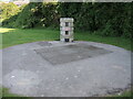
An odd round post in the park
At the edge of the playing surfaces of The Marsh is this concrete pillar and large manhole cover. The pillar is partly open and lined with grilles, and has running water inside it somewhere. Presumably this is water management in The Marsh - the clue might be in the name.
Image: © Neil Owen
Taken: 26 May 2023
0.07 miles
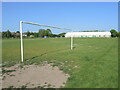
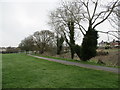
3
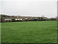
Football pitches at The Marsh Sports Ground
The first line of housing on the far side of the field is on Chickerell Road.
Image: © John Stephen
Taken: 10 Mar 2017
0.08 miles
5
Wearing out in The Marsh
It's late in the football season but the worn patch is not in the area of the goal, oddly.
Image: © Neil Owen
Taken: 26 May 2023
0.13 miles
6
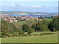
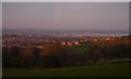
Curtis Fields, Weymouth
A haven of green fields (but under threat of development) within Weymouth's suburbs. From this point at the southern edge of the square, there is a dramatic view over the town and Weymouth Bay to the East Dorset coast beyond. View looking north-east.
Image: © Derek Harper
Taken: 19 Sep 2005
0.14 miles
7
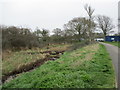
Marshy ground, The Marsh Sports Ground
Image: © John Stephen
Taken: 10 Mar 2017
0.15 miles
8
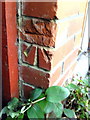
Benchmark on #4 Tennyson Road
Ordnance Survey cut mark benchmark described on the Bench Mark Database at http://www.bench-marks.org.uk/bm36365
Image: © Roger Templeman
Taken: 23 Dec 2010
0.15 miles
9
Semi on Tennyson Road from Pretoria Terrace
Image: © Roger Templeman
Taken: 23 Dec 2010
0.15 miles
10
The Marsh
Looking towards the swimming pool end.
Image: © John Stephen
Taken: 10 Mar 2017
0.16 miles