IMAGES TAKEN NEAR TO
Abbotsbury Road, WEYMOUTH, DT4 0AE
Introduction
This page details the photographs taken nearby to Abbotsbury Road, DT4 0AE by members of the Geograph project.
The Geograph project started in 2005 with the aim of publishing, organising and preserving representative images for every square kilometre of Great Britain, Ireland and the Isle of Man.

There are currently over 7.5m images from over14,400 individuals and you can help contribute to the project by visiting https://www.geograph.org.uk
Image Map (Loading...)


Getting Data...Please wait
Leaflet Map data © OpenStreetMap
Images are licensed for reuse under creativecommons.org/licenses/by-sa/2.0
Notes
- Clicking on the map will re-center to the selected point.
- The higher the marker number, the further away the image location is from the centre of the postcode.
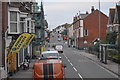
Image Listing (222 Images Found)
Images are licensed for reuse under creativecommons.org/licenses/by-sa/2.0
Image
Details
Distance
1
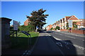
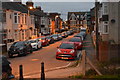
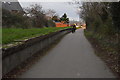
Abbotsbury Road
Looking west up Abbotsbury Road from the start of the Rodwell Trail.
Image: © John Stephen
Taken: 5 Sep 2012
0.02 miles
3
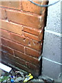
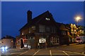
Benchmark on Holland House (#17 Abbotsbury Road)
Ordnance Survey cut mark benchmark described on the Bench Mark Database at http://www.bench-marks.org.uk/bm36399
Image: © Roger Templeman
Taken: 23 Dec 2010
0.02 miles
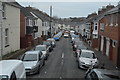
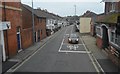
10
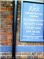
Benchmark on The Rock public house
Ordnance Survey cut mark benchmark described on the Bench Mark Database at http://www.bench-marks.org.uk/bm36355
Image: © Roger Templeman
Taken: 23 Dec 2010
0.06 miles