IMAGES TAKEN NEAR TO
Osmington, WEYMOUTH, DT3 6PH
Introduction
This page details the photographs taken nearby to DT3 6PH by members of the Geograph project.
The Geograph project started in 2005 with the aim of publishing, organising and preserving representative images for every square kilometre of Great Britain, Ireland and the Isle of Man.

There are currently over 7.5m images from over14,400 individuals and you can help contribute to the project by visiting https://www.geograph.org.uk
Image Map (Loading...)


Getting Data...Please wait
Leaflet Map data © OpenStreetMap
Images are licensed for reuse under creativecommons.org/licenses/by-sa/2.0
Notes
- Clicking on the map will re-center to the selected point.
- The higher the marker number, the further away the image location is from the centre of the postcode.
Image Listing (7 Images Found)
Images are licensed for reuse under creativecommons.org/licenses/by-sa/2.0
Image
Details
Distance
1
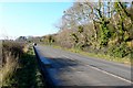
The A353 near Poxwell, Dorset
View west along the road towards Weymouth from close to Upton.
Image: © Nigel Mykura
Taken: 28 Dec 2008
0.05 miles
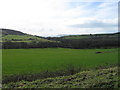
4
Countryside near Osmington
View SW across the square from close to where the Upton road leaves the A353
Image: © Nigel Mykura
Taken: 28 Dec 2008
0.16 miles
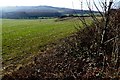
5
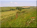
Downland, Poxwell
Pleasant pasture beside the bridleway southeast of Pixon Barn. The A353 is in the valley.
Image: © Andrew Smith
Taken: 8 Jun 2008
0.17 miles

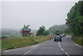
7
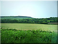
Looking south from the A353
Between Poxwell and Osmington
Image: © Chris Gunns
Taken: 25 May 2009
0.18 miles