IMAGES TAKEN NEAR TO
Blackberry Lane, WEYMOUTH, DT3 5RZ
Introduction
This page details the photographs taken nearby to Blackberry Lane, DT3 5RZ by members of the Geograph project.
The Geograph project started in 2005 with the aim of publishing, organising and preserving representative images for every square kilometre of Great Britain, Ireland and the Isle of Man.

There are currently over 7.5m images from over14,400 individuals and you can help contribute to the project by visiting https://www.geograph.org.uk
Image Map (Loading...)


Getting Data...Please wait
Leaflet Map data © OpenStreetMap
Images are licensed for reuse under creativecommons.org/licenses/by-sa/2.0
Notes
- Clicking on the map will re-center to the selected point.
- The higher the marker number, the further away the image location is from the centre of the postcode.
Image Listing (56 Images Found)
Images are licensed for reuse under creativecommons.org/licenses/by-sa/2.0
Image
Details
Distance
1

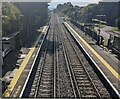
Railway from Upwey towards Weymouth
Looking south from Upwey station platform 2. Passenger trains stopping at Upwey are operated by South Western Railway and GWR in September 2022.
Image: © Jaggery
Taken: 23 Sep 2022
0.03 miles
3
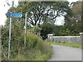
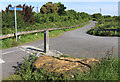
Bridge over railway south of Upwey and sign for NCN26
Image: © David Smith
Taken: 28 Sep 2020
0.08 miles
4

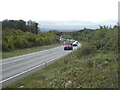
A354 at Upwey
A new road bypassing most of Upwey.
Image: © Des Blenkinsopp
Taken: 1 Jun 2019
0.08 miles
5
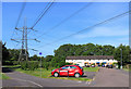
Juniper Way beneath the wires
Near Upwey Station.
Image: © Des Blenkinsopp
Taken: 1 Jun 2019
0.09 miles
7
South through Upwey station, Dorset
Viewed from the station footbridge. https://www.geograph.org.uk/photo/6205950 The next (and only) station ahead is the terminus at Weymouth.
Image: © Jaggery
Taken: 23 Sep 2022
0.10 miles
8
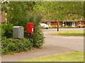
Broadwey: postbox № DT3 48, Bridlebank Way
A small postbox serving this fairly long reisdential road, with a drop box alongside (see below).
Image: © Chris Downer
Taken: 30 May 2010
0.12 miles
9

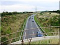
Pylon in the Sunset
Looking South from the 'Littlemoor Gap' pylon. The new Weymouth Relief Road will be directly under the wires.
Image: © Geoff Trim
Taken: 4 Dec 2008
0.12 miles
10
Sandstone by the Cycleway
A large slab beside the cycle route between Upwey and Weymouth, part of the Sustrans national cycle route 26 between the Somerset coast and Portland Bill.
Image: © Des Blenkinsopp
Taken: 1 Jun 2019
0.13 miles