IMAGES TAKEN NEAR TO
Kimmeridge Close, WEYMOUTH, DT3 5RL
Introduction
This page details the photographs taken nearby to Kimmeridge Close, DT3 5RL by members of the Geograph project.
The Geograph project started in 2005 with the aim of publishing, organising and preserving representative images for every square kilometre of Great Britain, Ireland and the Isle of Man.

There are currently over 7.5m images from over14,400 individuals and you can help contribute to the project by visiting https://www.geograph.org.uk
Image Map (Loading...)


Getting Data...Please wait
Leaflet Map data © OpenStreetMap
Images are licensed for reuse under creativecommons.org/licenses/by-sa/2.0
Notes
- Clicking on the map will re-center to the selected point.
- The higher the marker number, the further away the image location is from the centre of the postcode.
Image Listing (7 Images Found)
Images are licensed for reuse under creativecommons.org/licenses/by-sa/2.0
Image
Details
Distance
1
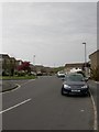
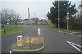
Radipole, Corfe Road
Housing development off Radipole Lane; local roads are named after Purbeck locations.
Image: © Mike Faherty
Taken: 16 Apr 2011
0.15 miles
2
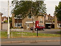
Radipole: postbox № DT3 150, Radipole Lane
A small postbox facing up Corfe Road, emptied finally at 4:30pm on weekdays and at 11am on Saturdays.
Image: © Chris Downer
Taken: 30 May 2010
0.16 miles
4
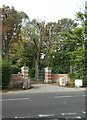
Entrance gates, Radipole Manor, Weymouth
Image: © David Smith
Taken: 28 Sep 2020
0.16 miles
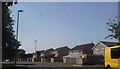
6
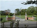
Entrance to Radipole Manor estate, Nottington, Weymouth
Image: © David Smith
Taken: 28 Sep 2020
0.17 miles
7
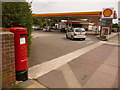
Radipole: postbox № DT3 99, Dorchester Road
A modern postbox by the entrance to a busy filling station. It is emptied finally at 5pm on weekdays and at noon on Saturdays.
Image: © Chris Downer
Taken: 30 May 2010
0.22 miles