IMAGES TAKEN NEAR TO
Littlemoor Road, WEYMOUTH, DT3 5PN
Introduction
This page details the photographs taken nearby to Littlemoor Road, DT3 5PN by members of the Geograph project.
The Geograph project started in 2005 with the aim of publishing, organising and preserving representative images for every square kilometre of Great Britain, Ireland and the Isle of Man.

There are currently over 7.5m images from over14,400 individuals and you can help contribute to the project by visiting https://www.geograph.org.uk
Image Map
Images are licensed for reuse under creativecommons.org/licenses/by-sa/2.0
Notes
- Clicking on the map will re-center to the selected point.
- The higher the marker number, the further away the image location is from the centre of the postcode.
Image Listing (77 Images Found)
Images are licensed for reuse under creativecommons.org/licenses/by-sa/2.0
Image
Details
Distance
1
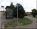
Cycle route 5 signpost, Littlemoor Road, Weymouth
The signpost is alongside National Cycle Network Route 5.
Left for Preston (Dorset) 2 miles away, right for Upwey railway
station (half a mile) and Weymouth town centre (3 miles).
Image: © Jaggery
Taken: 8 Sep 2018
0.02 miles
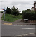
2
End of cycle route, Littlemoor Road, Weymouth
The sign is on the corner of the road named The Finches.
Image: © Jaggery
Taken: 8 Sep 2018
0.02 miles
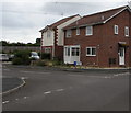
3
The Finches, Weymouth
The name sign is at the northern end of the road named The Finches, near the corner of Littlemoor Road.
The Finches leads to cul-de-sacs with bird-themed names such as Sanderling Close and Linnet Close.
Image: © Jaggery
Taken: 8 Sep 2018
0.02 miles
4
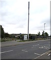
Telecoms mast and cabinets, Littlemoor Road, Weymouth
In the north of Weymouth, about 5km from the town centre.
Image: © Jaggery
Taken: 8 Sep 2018
0.03 miles
5
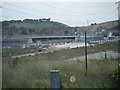
Obstructed Footpath
Weymouth Relief Road under construction at Littlemoor.
Image: © Ivan Hall
Taken: 19 Sep 2009
0.03 miles
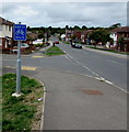
6
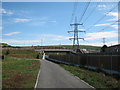
Roundabout over the Weymouth Relief Road
The Littlemoor Road crosses and joins the A354 Weymouth Relief Road under the cables of the National Grid. Image is clearly visible on the skyline. Seen from Image
Image: © Andy Potter
Taken: 25 Jul 2011
0.04 miles
7
Goldcrest Close, Weymouth
Cul-de-sac extending from the road named The Finches to vegetation and a wall below the A354 Weymouth Relief Road.
Image: © Jaggery
Taken: 8 Sep 2018
0.04 miles
8
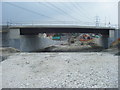
Littlemoor Road Bridge and Weymouth Relief Road
Rapidly taking shape. The roundabout on the OS maps is no more.
Image: © Ivan Hall
Taken: 19 Sep 2009
0.04 miles
9
Junction of Goldcrest Close and The Finches, Weymouth
Goldcrest Close http://www.geograph.org.uk/photo/5899113 from the left joins The Finches.
Image: © Jaggery
Taken: 8 Sep 2018
0.04 miles
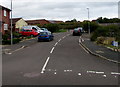
10
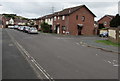
South along The Finches, Weymouth
The cars are parked in the road named The Finches, behind the right turn into Linnet Close. http://www.geograph.org.uk/photo/5899092
Image: © Jaggery
Taken: 8 Sep 2018
0.05 miles