IMAGES TAKEN NEAR TO
Turnstone Close, WEYMOUTH, DT3 5PL
Introduction
This page details the photographs taken nearby to Turnstone Close, DT3 5PL by members of the Geograph project.
The Geograph project started in 2005 with the aim of publishing, organising and preserving representative images for every square kilometre of Great Britain, Ireland and the Isle of Man.

There are currently over 7.5m images from over14,400 individuals and you can help contribute to the project by visiting https://www.geograph.org.uk
Image Map (Loading...)


Getting Data...Please wait
Leaflet Map data © OpenStreetMap
Images are licensed for reuse under creativecommons.org/licenses/by-sa/2.0
Notes
- Clicking on the map will re-center to the selected point.
- The higher the marker number, the further away the image location is from the centre of the postcode.
Image Listing (53 Images Found)
Images are licensed for reuse under creativecommons.org/licenses/by-sa/2.0
Image
Details
Distance
1
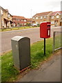
Littlemoor: postbox № DT3 85, Turnstone Close
This small postbox is emptied finally at 4pm on weekdays and at 8am on Saturdays. Alongside is a drop box (see below).
Pipit Close is the turning in the distance, named after a species of bird as with all the turnings along here.
Image: © Chris Downer
Taken: 30 May 2010
0.02 miles
2
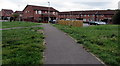
Path towards Turnstone Close and Kestrel View, Weymouth
Accessed from these https://www.geograph.org.uk/photo/5959215 steps down from Littlemoor Road.
Image: © Jaggery
Taken: 8 Sep 2018
0.04 miles
3
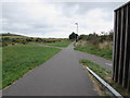
Path crossroads in the north of Weymouth
Viewed from the south side of Littlemoor Road.
Image: © Jaggery
Taken: 8 Sep 2018
0.06 miles
4
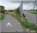
Footpath in the north of Weymouth
Part of the white symbol on the path is on the right here. https://www.geograph.org.uk/photo/5959394
The path on the right ascends towards Littlemoor Road.
Image: © Jaggery
Taken: 8 Sep 2018
0.06 miles
6
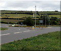
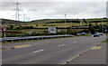
Towards Bincombe Bumps Roundabout, Weymouth
Looking east along Littlemoor Road towards the roundabout at the A353 junction.
The roundabout is near Iron Age barrows (burial mounds).
The mounds, known as the Bincombe Bumps, are close to the Southdown Ridge.
Image: © Jaggery
Taken: 8 Sep 2018
0.08 miles
7
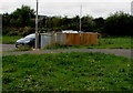
Kestrel View electricity substation, Weymouth
The SSE Power Distribution electricity substation is located near Kestrel View and Turnstone Close.
Image: © Jaggery
Taken: 8 Sep 2018
0.08 miles
8
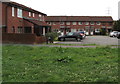
Kestrel View, Weymouth
Houses at the northern end of Kestrel View near Turnstone Close in the north of Weymouth.
Image: © Jaggery
Taken: 8 Sep 2018
0.08 miles
9
From 30 to 40 on Littlemoor Road, Weymouth
On the approach to the Bincombe Bumps Roundabout at the A353 junction,
the 30mph speed limit on Littlemoor Road increases to 40mph.
Image: © Jaggery
Taken: 8 Sep 2018
0.09 miles
10
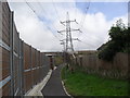
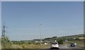
Upwey
A National Grid electricity pylon near the bridge of Littlemoor Road over Weymouth Relief Road.
Image: © Burgess Von Thunen
Taken: 14 Aug 2012
0.09 miles