IMAGES TAKEN NEAR TO
Anvil Close, WEYMOUTH, DT3 4GH
Introduction
This page details the photographs taken nearby to Anvil Close, DT3 4GH by members of the Geograph project.
The Geograph project started in 2005 with the aim of publishing, organising and preserving representative images for every square kilometre of Great Britain, Ireland and the Isle of Man.

There are currently over 7.5m images from over14,400 individuals and you can help contribute to the project by visiting https://www.geograph.org.uk
Image Map
Images are licensed for reuse under creativecommons.org/licenses/by-sa/2.0
Notes
- Clicking on the map will re-center to the selected point.
- The higher the marker number, the further away the image location is from the centre of the postcode.
Image Listing (81 Images Found)
Images are licensed for reuse under creativecommons.org/licenses/by-sa/2.0
Image
Details
Distance

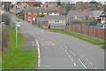
6
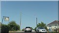
The south-west end of East Street, Chickerell
Which is to be found: south (and a little west) of the east end of West Street
Image: © David Smith
Taken: 24 Jan 2018
0.06 miles
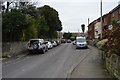
8
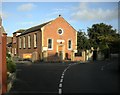
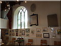
Chickerell Methodist Church
Dating from 1865.
Image: © Ian Rob
Taken: 2 Sep 2008
0.08 miles