IMAGES TAKEN NEAR TO
Hampton Close, WEYMOUTH, DT3 4EX
Introduction
This page details the photographs taken nearby to Hampton Close, DT3 4EX by members of the Geograph project.
The Geograph project started in 2005 with the aim of publishing, organising and preserving representative images for every square kilometre of Great Britain, Ireland and the Isle of Man.

There are currently over 7.5m images from over14,400 individuals and you can help contribute to the project by visiting https://www.geograph.org.uk
Image Map
Images are licensed for reuse under creativecommons.org/licenses/by-sa/2.0
Notes
- Clicking on the map will re-center to the selected point.
- The higher the marker number, the further away the image location is from the centre of the postcode.
Image Listing (92 Images Found)
Images are licensed for reuse under creativecommons.org/licenses/by-sa/2.0
Image
Details
Distance
1
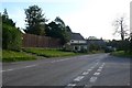
Portesham Dorset
View down Portesham hill towards the village. The road junction in the foreground is where the side street of Hampton joins Portesham Hill
Image: © Nigel Mykura
Taken: 24 Oct 2008
0.04 miles
2
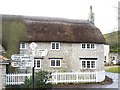
Portesham Village, Dorset
Entering the village from the north. Captain Thomas Hardy, one of Lord Nelson's commanders was born nearby and lived in the village. He is commemorated in the nearby Hardy Monument on Black Down.
Image: © Becky Williamson
Taken: 12 Jan 2015
0.04 miles
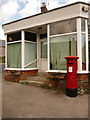
3
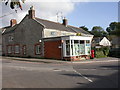
Portesham, post office
Post office and store at the junction of Front and Back Streets.
Image: © Mike Faherty
Taken: 10 Oct 2009
0.05 miles
4
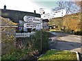
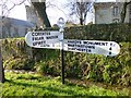
Old Direction Sign - Signpost by Front Street, Portesham
Annulus & bar finial - 3 arms; Dorset halo with NGR by the UC road, in parish of Portesham (West Dorset District), Front Street, junction with Back Street.
Surveyed
Milestone Society National ID: DO_SY6086
Image: © Milestone Society
Taken: Unknown
0.05 miles
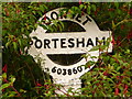
5
Portesham: postbox № DT3 80
This George VI-reign postbox stands outside the former post office and village store, which has only shut down in very recent months. The box is emptied finally at 4:15pm on weekdays and at 10am on Saturdays.
Image: © Chris Downer
Taken: 30 May 2010
0.07 miles
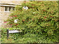
6
Portesham: finger-post detail
A close-up of the finial of the finger-post (see Image), giving location and grid reference details.
Image: © Chris Downer
Taken: 30 May 2010
0.07 miles
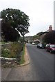
7
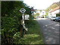
Portesham: almost hidden signpost
This traditional Dorset signpost, almost completely obscured by foliage, retains its original finial, giving location and grid reference details.
For a close-up of the finial, see Image
Image: © Chris Downer
Taken: 30 May 2010
0.07 miles
8
Front Street, Portesham
View up Front Street from the church gate. The stream runs alongside the road in a ditch crossed by stone flagged bridges.
Image: © John Stephen
Taken: 14 Aug 2013
0.13 miles
9
Old Direction Sign - Signpost by Front Street, Portesham Parish
Annulus and bar finial - 3 arms; Dorset halo with NGR by the UC road, in parish of Portesham (West Dorset District), Front Street, junction with Winter's Lane, near church.
Surveyed
Milestone Society National ID: DO_SY6085
Image: © Milestone Society
Taken: Unknown
0.14 miles
10
Portesham, fingerpost
Neglected Dorset fingerpost on Front Street, with one broken and one snapped arm.
Image: © Mike Faherty
Taken: 10 Oct 2009
0.14 miles