IMAGES TAKEN NEAR TO
Butter Street, WEYMOUTH, DT3 4EE
Introduction
This page details the photographs taken nearby to Butter Street, DT3 4EE by members of the Geograph project.
The Geograph project started in 2005 with the aim of publishing, organising and preserving representative images for every square kilometre of Great Britain, Ireland and the Isle of Man.

There are currently over 7.5m images from over14,400 individuals and you can help contribute to the project by visiting https://www.geograph.org.uk
Image Map
Images are licensed for reuse under creativecommons.org/licenses/by-sa/2.0
Notes
- Clicking on the map will re-center to the selected point.
- The higher the marker number, the further away the image location is from the centre of the postcode.
Image Listing (39 Images Found)
Images are licensed for reuse under creativecommons.org/licenses/by-sa/2.0
Image
Details
Distance
1
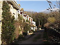
Butter Street
Attractive row of stone cottages at East Fleet, "Moonfleet Country".
Image: © Colin Smith
Taken: 15 Jan 2012
0.00 miles
2
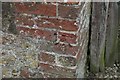
Benchmark, #1 Butter Street, East Fleet
Ordnance Survey benchmark, described on database at http://www.bench-marks.org.uk/bm75046. See also Image Most of the village of Fleet and the old church were destroyed during the great gale of November 1824.
Image: © Becky Williamson
Taken: 21 Apr 2016
0.01 miles

4
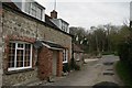
#1 Butter Street, East Fleet
There is an Ordnance Survey benchmark on this property. See Image Most of the village of Fleet and its old church was washed away during the great gale of November 1824.
Image: © Becky Williamson
Taken: 21 Apr 2016
0.01 miles
6
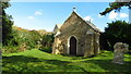
The old church at East Fleet near Chickerell
Image: © Colin Park
Taken: 12 Oct 2021
0.03 miles
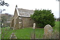
7
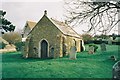
Fleet: the old parish church
All that remains of the old church at Fleet following the great storm of 1824.
Image: © Chris Downer
Taken: 2 Sep 1992
0.03 miles
8
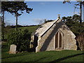
Old Fleet Church
Historic church by The Fleet. It was superseded by a new church a short distance to the north because of storm damage which burst Chesil Bank at the time.
Image: © Colin Smith
Taken: 15 Jan 2012
0.03 miles
9
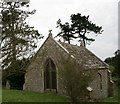
Fleet Old Church
Only the chancel remains of this building after the great gale destroyed the rest of it, along with most of the village in November 1824. The building's vaults were once the hiding place for smuggling contraband, as described in J Meade Falkner's book 'Moonfleet'.
Image: © Becky Williamson
Taken: 21 Apr 2016
0.03 miles
10
Old Parish Church, East Fleet
Grade II* listed. https://historicengland.org.uk/listing/the-list/list-entry/1118700
Image: © N Chadwick
Taken: 31 Dec 2018
0.03 miles