IMAGES TAKEN NEAR TO
Bull Close, DORCHESTER, DT2 9TQ
Introduction
This page details the photographs taken nearby to Bull Close, DT2 9TQ by members of the Geograph project.
The Geograph project started in 2005 with the aim of publishing, organising and preserving representative images for every square kilometre of Great Britain, Ireland and the Isle of Man.

There are currently over 7.5m images from over14,400 individuals and you can help contribute to the project by visiting https://www.geograph.org.uk
Image Map
Images are licensed for reuse under creativecommons.org/licenses/by-sa/2.0
Notes
- Clicking on the map will re-center to the selected point.
- The higher the marker number, the further away the image location is from the centre of the postcode.
Image Listing (66 Images Found)
Images are licensed for reuse under creativecommons.org/licenses/by-sa/2.0
Image
Details
Distance
1
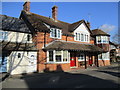
The Old Bull Inn, Stratton
The Bull Inn had been closed for several months in 1989 when permission was granted to allow development of residential housing on adjoining land which was used as part of the pub car park, which became Bull Close. A condition was made that the pub building and its remaining land retained their use for three years from the date of occupancy of the residential units. This condition expired in 1994, by which time it had proved impossible to sell the pub as a going concern. The pub was then converted to housing. Two years ago the front of the building had to be renovated due to traffic damage, which would seem to be extraordinary given the main road bypasses the village completely.
Image: © John Stephen
Taken: 6 Feb 2018
0.02 miles
2
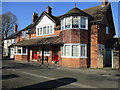
The Old Bull Inn, Stratton
The Bull Inn had been closed for several months in 1989 when permission was granted to allow development of residential housing on adjoining land which was used as part of the pub car park, which became Bull Close. A condition was made that the pub building and its remaining land retained their use for three years from the date of occupancy of the residential units. This condition expired in 1994, by which time it had proved impossible to sell the pub as a going concern. The pub was then converted to housing. Two years ago the front of the building had to be renovated due to traffic damage, which would seem to be extraordinary given the main road bypasses the village completely.
Image: © John Stephen
Taken: 6 Feb 2018
0.02 miles
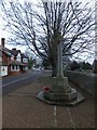
4
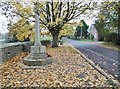
Stratton, war memorial
On Dorchester Road; recording the names of thirteen fallen in the world wars.
Image: © Mike Faherty
Taken: 3 Nov 2015
0.03 miles
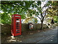
5
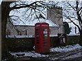
Stratton: the telephone box
Stratton's telephone box is a traditional red one, standing outside the parish church.
Image: © Chris Downer
Taken: 19 Jan 2013
0.03 miles
9
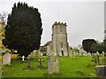
Stratton, St. Mary the Virgin
Parish church on Dorchester Road, dating from C12; listed by Historic England (Grade I): http://www.imagesofengland.org.uk/Details/Default.aspx?id=401939&mode=adv
Image: © Mike Faherty
Taken: 3 Nov 2015
0.05 miles
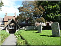
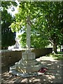
10
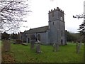
Stratton church and churchyard
A Norman church dedicated to St Mary
Image: © David Smith
Taken: 27 Dec 2013
0.05 miles