IMAGES TAKEN NEAR TO
Old Sherborne Road, DORCHESTER, DT2 9RH
Introduction
This page details the photographs taken nearby to Old Sherborne Road, DT2 9RH by members of the Geograph project.
The Geograph project started in 2005 with the aim of publishing, organising and preserving representative images for every square kilometre of Great Britain, Ireland and the Isle of Man.

There are currently over 7.5m images from over14,400 individuals and you can help contribute to the project by visiting https://www.geograph.org.uk
Image Map (Loading...)


Getting Data...Please wait
Leaflet Map data © OpenStreetMap
Images are licensed for reuse under creativecommons.org/licenses/by-sa/2.0
Notes
- Clicking on the map will re-center to the selected point.
- The higher the marker number, the further away the image location is from the centre of the postcode.
Image Listing (5 Images Found)
Images are licensed for reuse under creativecommons.org/licenses/by-sa/2.0
Image
Details
Distance
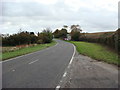
2
Leap Gate north of Charminster
On Old Sherborne Road
Image: © John Firth
Taken: 12 Apr 2013
0.01 miles
3
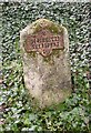
Old Milestone by the UC road, north east of Charminster
Metal plate attached to stone post by the UC road, in parish of CHARMINSTER (WEST DORSET District), half mile North of Charminster; 75m South of house called 'Leap Gate', 4 metres back from road by hedge, on West side of road. Dorset 1 and 4 (iron plated), erected by the Weymouth, Melcombe Regis & Dorchester turnpike trust in the 19th century.
Inscription reads:-
2
DORCHESTER
SHERBORNE
16
Milestone Society National ID: DO_DOSB02
Image: © Mike Faherty
Taken: 27 Feb 2011
0.05 miles
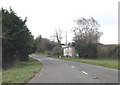
4
Charminster, Old Sherborne Road
The older road from Dorchester to Sherborne, roughly along Wessex Ridgeway; seen North of Leap Gate.
Image: © Mike Faherty
Taken: 27 Feb 2011
0.08 miles
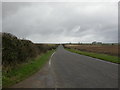
5

Wolfedale Golf Course
View north from the minor road to the clubhouse just off the minor road C12.
Image: © Nigel Mykura
Taken: 5 Aug 2008
0.17 miles