IMAGES TAKEN NEAR TO
Meadow View, DORCHESTER, DT2 9RE
Introduction
This page details the photographs taken nearby to Meadow View, DT2 9RE by members of the Geograph project.
The Geograph project started in 2005 with the aim of publishing, organising and preserving representative images for every square kilometre of Great Britain, Ireland and the Isle of Man.

There are currently over 7.5m images from over14,400 individuals and you can help contribute to the project by visiting https://www.geograph.org.uk
Image Map
Images are licensed for reuse under creativecommons.org/licenses/by-sa/2.0
Notes
- Clicking on the map will re-center to the selected point.
- The higher the marker number, the further away the image location is from the centre of the postcode.
Image Listing (113 Images Found)
Images are licensed for reuse under creativecommons.org/licenses/by-sa/2.0
Image
Details
Distance
1
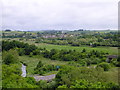
Charminster from The Roman Aqueduct
The road in the foreground is the A37 Weymouth to Yeovil Road and forms part of the Dorchester bypass. The river is the River Frome and the bridge on the right is that that carries the railway between Weymouth and Yeovil Pen Mill
Image: © Ian Andrews
Taken: 21 Jun 2013
0.05 miles
2
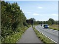
Covid-19 sign by A37 near Charminster
Stay alert/Control the virus/Save lives ... and cyclists must stay alert because the pillar is in the cycle path
Image: © David Smith
Taken: 26 Aug 2020
0.06 miles
3
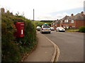
Charminster: postbox № DT2 70, Pound Close
This little postbox serves western Charminster and is emptied at quarter past eleven each morning, except Sundays.
Image: © Chris Downer
Taken: 7 Jun 2009
0.08 miles
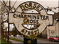
4
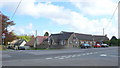
Charminster Cross
This is the main crossroads in the village where the A352 Dorchester to Sherborne road crosses the old road past the church. In the background is the village hall.
Image: © Nigel Mykura
Taken: 2 May 2008
0.10 miles
5
Charminster: detail of finger-post finial
A close-up of the finial of the finger-post (see Image), giving location and grid reference details.
Image: © Chris Downer
Taken: 3 Apr 2010
0.11 miles
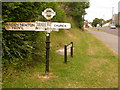
6

Charminster Cross
The sign post at the cross roads in the centre of the village
Image: © Nigel Mykura
Taken: 2 May 2008
0.11 miles
7
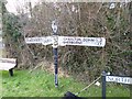
Charminster: old Dorset finger-post
One of many surviving Dorset finger-posts, complete with the finial which states location and grid reference.
For a close-up of the finial, see Image
Image: © Chris Downer
Taken: 7 Jun 2009
0.12 miles
8
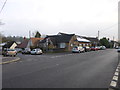
Charminster Village Hall
At the corner of North Street and West Hill: http://www.charminstervillagehall.co.uk/
Image: © Mike Faherty
Taken: 24 Jan 2013
0.12 miles
10
Direction Sign - Signpost by the A352, Charminster Cross
Annulus and bar finial - 4 arms; Dorset halo with NGR by the A352, in parish of Charminster (West Dorset District), Charminster Cross, junction of West Hill with North Street, on verge below grass bank.
Surveyed
Milestone Society National ID: DO_SY6792
Image: © Milestone Society
Taken: Unknown
0.13 miles