IMAGES TAKEN NEAR TO
Greenacre, DORCHESTER, DT2 9QW
Introduction
This page details the photographs taken nearby to Greenacre, DT2 9QW by members of the Geograph project.
The Geograph project started in 2005 with the aim of publishing, organising and preserving representative images for every square kilometre of Great Britain, Ireland and the Isle of Man.

There are currently over 7.5m images from over14,400 individuals and you can help contribute to the project by visiting https://www.geograph.org.uk
Image Map (Loading...)


Getting Data...Please wait
Leaflet Map data © OpenStreetMap
Images are licensed for reuse under creativecommons.org/licenses/by-sa/2.0
Notes
- Clicking on the map will re-center to the selected point.
- The higher the marker number, the further away the image location is from the centre of the postcode.
Image Listing (125 Images Found)
Images are licensed for reuse under creativecommons.org/licenses/by-sa/2.0
Image
Details
Distance
1
Miller's Community Orchard, Charminster
Image: © Becky Williamson
Taken: 6 May 2016
0.05 miles
2
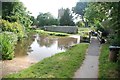
Alley Bridge, Charminster
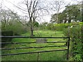
Immediately behind the churchyard, many centuries ago this was the meeting point of a number of ancient trackways which forded the river at this shallow point.
Image: © Alan J Brown
Taken: 23 Oct 2007
0.06 miles
3
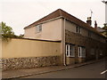
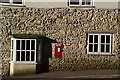
Charminster: the old post office
The old post office in East Hill. The post office relocated to a general shop in Cocklands, up the hill, about 20 years ago and it is still there. There is a 'Ludlow' postbox, still in use, set into the wall – see Image
Image: © Chris Downer
Taken: 7 Jun 2009
0.07 miles
4
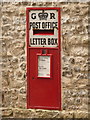
Charminster: postbox № DT2 121, East Hill
This postbox is set into the wall of the Image and is an example of a 'Ludlow' box, named after its designer and intended particularly for sub post offices. This one is emptied finally at 5pm on weekdays and at 11:15am on Saturdays.
Image: © Chris Downer
Taken: 7 Jun 2009
0.07 miles
5
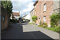
GR postbox in wall, Charminster
In the wall of a cottage on East Hill.
Image: © Peter Barr
Taken: 26 Apr 2013
0.07 miles
6
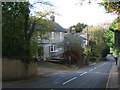
East Hill, Charminster
Looking down East Hill towards the church (hidden by the trees). The buildings on the left have been altered in recent years, the furthest one used to be a non-conformist chapel.
Image: © Alan J Brown
Taken: 30 Oct 2007
0.08 miles
8
Footbridge over the River Char
One of many paths running around the village.
The church of St Mary the Virgin is to the left of the picture.
Watercress can be seen at the waterside.
Image: © Anthony Vosper
Taken: 29 Aug 2012
0.09 miles
9
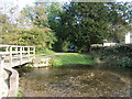
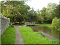
Ford at Charminster
One of two fords at Charminster this one is found on the River Cerne opposite the church.
Image: © John Walton
Taken: 27 Jun 2015
0.09 miles
10
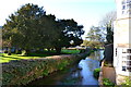
River Cerne, Charminster
Passing St. John's Church, the small river flows under the bridge which separates East Hill and West Hill.
Image: © Peter Barr
Taken: 26 Apr 2013
0.09 miles