IMAGES TAKEN NEAR TO
East Street, DORCHESTER, DT2 9NX
Introduction
This page details the photographs taken nearby to East Street, DT2 9NX by members of the Geograph project.
The Geograph project started in 2005 with the aim of publishing, organising and preserving representative images for every square kilometre of Great Britain, Ireland and the Isle of Man.

There are currently over 7.5m images from over14,400 individuals and you can help contribute to the project by visiting https://www.geograph.org.uk
Image Map (Loading...)


Getting Data...Please wait
Leaflet Map data © OpenStreetMap
Images are licensed for reuse under creativecommons.org/licenses/by-sa/2.0
Notes
- Clicking on the map will re-center to the selected point.
- The higher the marker number, the further away the image location is from the centre of the postcode.
Image Listing (123 Images Found)
Images are licensed for reuse under creativecommons.org/licenses/by-sa/2.0
Image
Details
Distance
1
Wessex Ridgeway in Sydling St.Nicholas
The trail adopts a route on East Street as it approaches the village green in Sydling St. Nicholas
Image: © Chris Heaton
Taken: 4 Feb 2019
0.01 miles
2
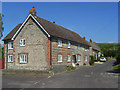
East Street, Sydling St Nicholas
With the Old School House in the foreground.
Image: © Andrew Smith
Taken: 27 Jul 2008
0.03 miles
3
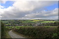
Approaching Sydling St Nicholas from the east
The Wessex Ridgeway path descending Eastfield Hill
Image: © Tim Heaton
Taken: 4 Feb 2019
0.03 miles
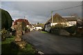
4
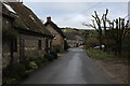
Houses, East Street, Sydling St. Nicholas
Grade II listed buildings.
Image: © Robin Webster
Taken: 4 Jun 2017
0.04 miles
5

Goose - Sydling St Nicholas
The geese have a lovely stretch of Sydling Water which is safely fenced off from the lane.
Image: © Sarah Smith
Taken: 12 Nov 2008
0.05 miles
6

Geese on Sydling Water
Sydling Water rises in Upsydling and flows down through the village to just the other side of Grimstone where it joins the River Frome.
Image: © Sarah Smith
Taken: 12 Nov 2008
0.05 miles
7
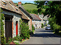
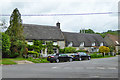
East Street, Sydling St Nicholas
A road of attractive cottages leading away from the village centre and nestling beneath the downs.
Image: © Andrew Smith
Taken: 27 Jul 2008
0.05 miles
8
Old cross and village scene, Sydling St Nicholas
The cross is thought to be from around the 15th Century and stands at an ancient crossroads. A school used to be nearby and the cross apparently eroded through school children playing around it.
Image: © Becky Williamson
Taken: 31 Jan 2015
0.07 miles
9
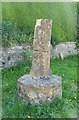
Old Central Cross by High Street, Sydling St Nicholas
Sydling Market Cross, old shaft and base, by the UC road, in parish of Sydling St Nicholas (West Dorset District), High Street, junction with East Street and Church Lane, on verge at crossroads.
Grade II listed.
List Entry Number: 1302861 https://historicengland.org.uk/listing/the-list/list-entry/1302861
Surveyed
Milestone Society National ID: DOWD_SYD
Image: © Alan Rosevear
Taken: 23 May 2012
0.07 miles
10
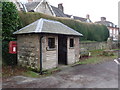
Sydling St. Nicholas: postbox № DT2 134 and bus shelter
Two village amenities standing at the main village crossroads. The bus shelter is packed with various notices and was erected, according to the stone on the left, to mark the Queen's coronation in 1953. The postbox is emptied at 4:30pm on weekdays and at 10:15am on Saturdays.
Image: © Chris Downer
Taken: 23 Jan 2011
0.07 miles