IMAGES TAKEN NEAR TO
Sydling St. Nicholas, DORCHESTER, DT2 9NP
Introduction
This page details the photographs taken nearby to DT2 9NP by members of the Geograph project.
The Geograph project started in 2005 with the aim of publishing, organising and preserving representative images for every square kilometre of Great Britain, Ireland and the Isle of Man.

There are currently over 7.5m images from over14,400 individuals and you can help contribute to the project by visiting https://www.geograph.org.uk
Image Map (Loading...)


Getting Data...Please wait
Leaflet Map data © OpenStreetMap
Images are licensed for reuse under creativecommons.org/licenses/by-sa/2.0
Notes
- Clicking on the map will re-center to the selected point.
- The higher the marker number, the further away the image location is from the centre of the postcode.
Image Listing (4 Images Found)
Images are licensed for reuse under creativecommons.org/licenses/by-sa/2.0
Image
Details
Distance
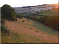
1

Langford Farm
In the valley of the Sydling Water.
Image: © Robin Webster
Taken: 4 Jun 2017
0.05 miles
2

Sydling Water
Ducks sunning themselves by the side of the Sydling Water just where the road from Grimstone to Sydling bridges the stream
Image: © Nigel Mykura
Taken: 7 Mar 2008
0.09 miles
3
Grimstone Down
A dry valley on the northern side of the down leading down to Langford Farm in the Sydling valley.
Image: © Andrew Smith
Taken: 27 Jul 2008
0.19 miles
4
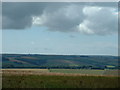
View from Grimstone Down southwest
the houses on the intermediate ridge are at Long Ash Lane garage above Frampton on the A37
Image: © Val Ghose
Taken: 23 Jul 2006
0.24 miles