IMAGES TAKEN NEAR TO
North Park, DORCHESTER, DT2 9NN
Introduction
This page details the photographs taken nearby to North Park, DT2 9NN by members of the Geograph project.
The Geograph project started in 2005 with the aim of publishing, organising and preserving representative images for every square kilometre of Great Britain, Ireland and the Isle of Man.

There are currently over 7.5m images from over14,400 individuals and you can help contribute to the project by visiting https://www.geograph.org.uk
Image Map (Loading...)


Getting Data...Please wait
Leaflet Map data © OpenStreetMap
Images are licensed for reuse under creativecommons.org/licenses/by-sa/2.0
Notes
- Clicking on the map will re-center to the selected point.
- The higher the marker number, the further away the image location is from the centre of the postcode.
Image Listing (107 Images Found)
Images are licensed for reuse under creativecommons.org/licenses/by-sa/2.0
Image
Details
Distance
1
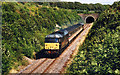
Frampton Tunnel
Railway Tunnel at Frampton.
Image: © Wayland Smith
Taken: 20 Jul 2002
0.02 miles
2
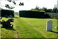
Frampton Cemetery and Allotments
There is a small overflow cemetery in the village just north of the railway line and it occupies a portion of a field of which the major part consists of allotments.
Image: © Nigel Mykura
Taken: 24 Jul 2008
0.06 miles
3
Bristol to Weymouth rail line at Frampton
Taken from Frampton Road Bridge, looking towards Dorchester. The distant tunnel is in the next square to the east.
Image: © Maurice D Budden
Taken: 5 Sep 2019
0.06 miles
4
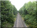
Railway Cutting, Frampton
Looking SE from the bridge just north of the village. This is part of the Dorchester to Yeovil line.
Image: © Nigel Mykura
Taken: 24 Jul 2008
0.10 miles
5
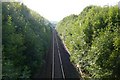
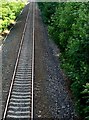
Railway cutting, Frampton
A view NW along the Dorchester to Yeovil line just north of the village.
Image: © Nigel Mykura
Taken: 24 Jul 2008
0.14 miles
6
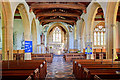
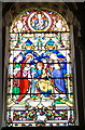
St Mary's parish church - Frampton (interior)
A view of the nave and beyond to the chancel arch. Glimpses of three of the Browne monuments are visible in the north aisle to the left.
Image: © Mike Searle
Taken: 24 May 2011
0.15 miles
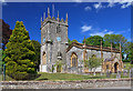
7
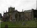
The Church of St Mary at Frampton
Viewed from the south east.
Image: © Peter Wood
Taken: 31 Mar 2014
0.16 miles
8
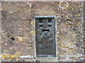
Ordnance Survey Flush Bracket 214
This can be found on the wall of St Mary's Church at Frampton.
For more detail see : http://www.bench-marks.org.uk/bm1209
Image: © Peter Wood
Taken: 31 Mar 2014
0.16 miles
10
St Mary's parish church - Frampton
Robert Browne of Frampton Court built the tower in 1695.
Image: © Mike Searle
Taken: 24 May 2011
0.17 miles