IMAGES TAKEN NEAR TO
Long Bredy, DORCHESTER, DT2 9JB
Introduction
This page details the photographs taken nearby to DT2 9JB by members of the Geograph project.
The Geograph project started in 2005 with the aim of publishing, organising and preserving representative images for every square kilometre of Great Britain, Ireland and the Isle of Man.

There are currently over 7.5m images from over14,400 individuals and you can help contribute to the project by visiting https://www.geograph.org.uk
Image Map
Images are licensed for reuse under creativecommons.org/licenses/by-sa/2.0
Notes
- Clicking on the map will re-center to the selected point.
- The higher the marker number, the further away the image location is from the centre of the postcode.
Image Listing (95 Images Found)
Images are licensed for reuse under creativecommons.org/licenses/by-sa/2.0
Image
Details
Distance
1
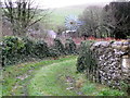
Track, Long Bredy
The track acts as a footpath that takes walkers towards Hut Lane. There is an old wind pump in the garden beside the track.
Image: © Maigheach-gheal
Taken: 1 Jan 2012
0.03 miles
2
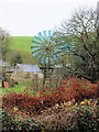
Old wind-pump
The old wind-pump is found in a garden close to the church.
Image: © Jonathan Kington
Taken: 1 Jan 2012
0.03 miles
4
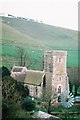
Long Bredy: church and windpump from up the hill
Looking down on the Image
Image: © Chris Downer
Taken: Unknown
0.04 miles
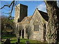
5
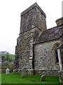
Church tower, The Church of St Peter
The church tower dates from the 15th century and is built of rubble stone and flint.
Image: © Maigheach-gheal
Taken: 1 Jan 2012
0.04 miles
6
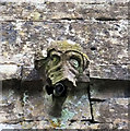
Gargoyle (1)
One of four gargoyles to be found on the tower of St Peter's church. See also Image, Image and Image
Architects often used a series of gargoyles on a building to divide the flow of rainwater off the roof so as to minimize the potential damage from a rainstorm, especially the washing out of mortar between the stones. A trough is cut in the back of the gargoyle and rainwater typically exits through the open mouth.
Image: © Jonathan Kington
Taken: 1 Jan 2012
0.04 miles
7

The ceiling
The nave ceiling of St Peter's Church is supported by eight 19th century carved stone corbels, four on each side. There are four bays of arch-braced collar-trusses with splayed 'Y'-strutting above them.
Image: © Jonathan Kington
Taken: 1 Jan 2012
0.04 miles
8
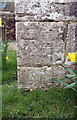
Benchmark on St Peter's Church
Ordnance Survey cut mark benchmark described on the Bench Mark Database at http://www.bench-marks.org.uk/bm40810
Image: © Roger Templeman
Taken: 28 Mar 2015
0.04 miles
9
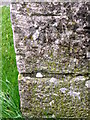
Bench Mark, The Church of St Peter, Long Bredy
The Ordnance Survey bench mark is to be found on the church tower. For a wider view Image and for further information on the cut mark and others in the area http://www.bench-marks.org.uk/bm40810
Image: © Maigheach-gheal
Taken: 1 Jan 2012
0.04 miles
10
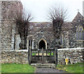
Gate to the church
The path to the church leads between two pollarded Limes and up to the South door. The parishioners hereabouts seem to be a little superstitious having fastened a horseshoe to the gatepost for luck!
Image: © Jonathan Kington
Taken: 1 Jan 2012
0.04 miles