IMAGES TAKEN NEAR TO
Herrison Road, DORCHESTER, DT2 9FP
Introduction
This page details the photographs taken nearby to Herrison Road, DT2 9FP by members of the Geograph project.
The Geograph project started in 2005 with the aim of publishing, organising and preserving representative images for every square kilometre of Great Britain, Ireland and the Isle of Man.

There are currently over 7.5m images from over14,400 individuals and you can help contribute to the project by visiting https://www.geograph.org.uk
Image Map (Loading...)


Getting Data...Please wait
Leaflet Map data © OpenStreetMap
Images are licensed for reuse under creativecommons.org/licenses/by-sa/2.0
Notes
- Clicking on the map will re-center to the selected point.
- The higher the marker number, the further away the image location is from the centre of the postcode.
Image Listing (13 Images Found)
Images are licensed for reuse under creativecommons.org/licenses/by-sa/2.0
Image
Details
Distance
1
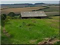
Barn, Charlton Down
You can also see another barn on the way across the down towards Forston.
Image: © Andrew Smith
Taken: 27 Aug 2007
0.12 miles
2
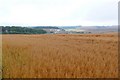
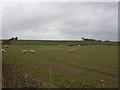
Cornfield at Charlton Higher Down
View SW towards the new housing at Charlton Down which can be seen in the distance. The name Charlton comes from the place where Ceorls (pronounced churls) live. Ceorls were free peasants who lived in Anglo Saxon times. We still use a derivative of this word in "churlish". It originally meant of lower social class. So people who live in Charlton are peasants!
Image: © Nigel Mykura
Taken: 6 Aug 2008
0.12 miles
3

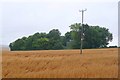
Copse, Charlton Down
A copse hiding a reservoir just to the west of the junction at Roman Road Farm.
Image: © Andrew Smith
Taken: 27 Aug 2007
0.15 miles
4
Charlton Higher Down
This clump of trees contains a covered reservoir on top of which is a significant metal tower.
Image: © Nigel Mykura
Taken: 6 Aug 2008
0.16 miles
5
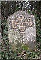
Old Milestone by the UC road, east of Charlton Down
Metal plate attached to stone post by the UC road, in parish of CHARMINSTER (WEST DORSET District), 300m South of junction to Herrison House/Hospital, on a slight bend opposite a small layby, 1 metre back from road against hedge, on West side of road. Dorset 1 and 4 (iron plated), erected by the Weymouth, Melcombe Regis & Dorchester turnpike trust in the 19th century.
Inscription reads:-
3
DORCHESTER
SHERBORNE
15
Carved benchmark lower mid front.
Milestone Society National ID: DO_DOSB03
Image: © Mike Faherty
Taken: 27 Feb 2011
0.17 miles
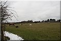
6
Charminster, sheep grazing
On Charlton Higher Down.
Image: © Mike Faherty
Taken: 27 Feb 2011
0.18 miles
7
Roman Road Farm in winter
A menagerie of animals lives here.
Image: © Becky Williamson
Taken: 22 Mar 2018
0.20 miles
8
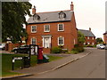
Charlton Down: postbox № DT2 213, Meech Way
This Elizabeth II-reign postbox serves the eastern half of the Charlton Down estate and is emptied at 11am each morning except Sunday.
Image: © Chris Downer
Taken: 7 Jun 2009
0.20 miles
9
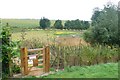
Charlton Down Nature Reserve
This small reserve has been built on the edge of the housing development at the old Herrison Hospital just outside Dorchester.
Image: © Nigel Mykura
Taken: 6 Aug 2008
0.22 miles
10

Charlton Down
Houses on the new residential development where it abuts open farmland.
Image: © Andrew Smith
Taken: 27 Aug 2007
0.24 miles