IMAGES TAKEN NEAR TO
Laburnum Road, DORCHESTER, DT2 9FE
Introduction
This page details the photographs taken nearby to Laburnum Road, DT2 9FE by members of the Geograph project.
The Geograph project started in 2005 with the aim of publishing, organising and preserving representative images for every square kilometre of Great Britain, Ireland and the Isle of Man.

There are currently over 7.5m images from over14,400 individuals and you can help contribute to the project by visiting https://www.geograph.org.uk
Image Map
Images are licensed for reuse under creativecommons.org/licenses/by-sa/2.0
Notes
- Clicking on the map will re-center to the selected point.
- The higher the marker number, the further away the image location is from the centre of the postcode.
Image Listing (15 Images Found)
Images are licensed for reuse under creativecommons.org/licenses/by-sa/2.0
Image
Details
Distance
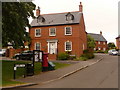
1

Charlton Down
Houses on the new residential development where it abuts open farmland.
Image: © Andrew Smith
Taken: 27 Aug 2007
0.04 miles
2

Cypress Road, Charlton Down
Charlton Down seems like a rather nice estate located next to open countryside above the Cerne valley. This view looks into the estate from its northern edge.
Image: © Andrew Smith
Taken: 27 Aug 2007
0.04 miles
3
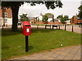
Charlton Down: postbox № DT2 536, Sherren Avenue
This modern postbox is at the western part of Charlton Down, outside the general store. It is emptied at 4:15pm on weekdays and at 11am on Saturdays.
For more discussion of the Charlton Down estate, see Image
Image: © Chris Downer
Taken: 7 Jun 2009
0.15 miles
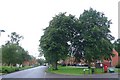
4
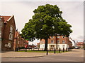
Charlton Down: large tree in village centre
This large tree stands by the village shop, whose frontage is just about in picture on the left-hand edge. For more about this development, see Image
Image: © Chris Downer
Taken: 7 Jun 2009
0.15 miles
5
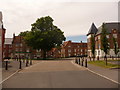
Charlton Down: Sherren Avenue
Here we look along Sherren Avenue, the central thoroughfare of the Charlton Down estate.
The estate occupies a 400-acre site which was the Herrison Mental Hospital, an asylum which had opened in Victorian times and became the Dorset County Mental Hospital in 1920 before taking the Herrison name in 1940.
The three major buildings were redeveloped, following the abandonment of the site in the early 1990s, into dwellings and hundreds of houses, such as those pictured, were built on the surrounding land.
Image: © Chris Downer
Taken: 7 Jun 2009
0.15 miles
7
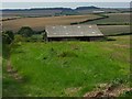
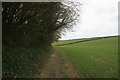
Barn, Charlton Down
You can also see another barn on the way across the down towards Forston.
Image: © Andrew Smith
Taken: 27 Aug 2007
0.17 miles
8
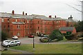
Part of Herrison House, Charlton Down
Once a mental institution, this austere building has been converted into flats forming part of the village of Charlton Down near Charminster.
Image: © Becky Williamson
Taken: 22 Mar 2018
0.18 miles
9
Charlton Down: postbox № DT2 213, Meech Way
This Elizabeth II-reign postbox serves the eastern half of the Charlton Down estate and is emptied at 11am each morning except Sunday.
Image: © Chris Downer
Taken: 7 Jun 2009
0.18 miles
10
Houses at Charlton Down
Charlton Down is a new village built on the site of Herrison hospital which used to be Dorset County Mental Hospital. Many of the old hospital buildings have been converted to apartments and housing as well as many new houses being built.
Image: © Nigel Mykura
Taken: 6 Aug 2008
0.18 miles