IMAGES TAKEN NEAR TO
Winterbourne Steepleton, DORCHESTER, DT2 9DX
Introduction
This page details the photographs taken nearby to DT2 9DX by members of the Geograph project.
The Geograph project started in 2005 with the aim of publishing, organising and preserving representative images for every square kilometre of Great Britain, Ireland and the Isle of Man.

There are currently over 7.5m images from over14,400 individuals and you can help contribute to the project by visiting https://www.geograph.org.uk
Image Map
Images are licensed for reuse under creativecommons.org/licenses/by-sa/2.0
Notes
- Clicking on the map will re-center to the selected point.
- The higher the marker number, the further away the image location is from the centre of the postcode.
Image Listing (22 Images Found)
Images are licensed for reuse under creativecommons.org/licenses/by-sa/2.0
Image
Details
Distance
1
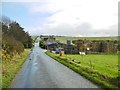
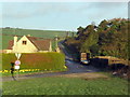
Winterbourne Abbas, Sunnyside Farm
At the junction of Bridport and Roman Roads; former farm, now pallet dealers.
Image: © Mike Faherty
Taken: 27 Nov 2015
0.07 miles
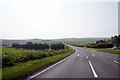
2
A35 heading west
A Roman road, but the A35 swings left at the bottom of the hill, leaving the Roman route to continue as an unclassified road.
Image: © Robin Webster
Taken: 18 Jul 2019
0.08 miles
3
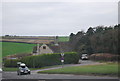
Bradford Peverell: field on Knowle Hill
The corner of a wood provides the backdrop of this field on the slopes of Knowle Hill, in the southwestern corner of Bradford Peverell parish.
Image: © Chris Downer
Taken: 27 Sep 2008
0.09 miles
4
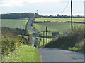
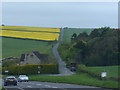
Roman Road near Winterbourne Steepleton
This road forks off the A35 at Lambert's Hill, and goes as straight as it can (which is not particularly straight in this hilly countryside) towards Eggardon Hill. The sharp bend in the picture is a 20th century diversion to make the junction with the main road safer. The original course of the road continues under the grass.
Image: © Stephen Williams
Taken: 11 Mar 2007
0.09 miles
5
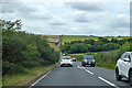
On the A35 at Lambert's Hill
Where it deviates from the course of the Roman road.
Image: © Chris Gunns
Taken: 2 May 2014
0.10 miles
7
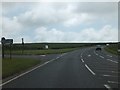
A35 junction on Lambert's Hill
This junction is where the A35 joins the Roman road from Compton Valence. From here to Dorchester, the A35 follows the course that the Romans used.
Image: © David Smith
Taken: 16 Jun 2012
0.11 miles
9
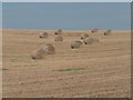
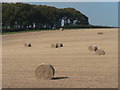
Bradford Peverell: bales in field
Bales in a field in the southwestern corner of the parish of Bradford Peverell, part of Higher Skippet Farm.
Image: © Chris Downer
Taken: 27 Sep 2008
0.12 miles