IMAGES TAKEN NEAR TO
Church Street, DORCHESTER, DT2 9BN
Introduction
This page details the photographs taken nearby to Church Street, DT2 9BN by members of the Geograph project.
The Geograph project started in 2005 with the aim of publishing, organising and preserving representative images for every square kilometre of Great Britain, Ireland and the Isle of Man.

There are currently over 7.5m images from over14,400 individuals and you can help contribute to the project by visiting https://www.geograph.org.uk
Image Map
Images are licensed for reuse under creativecommons.org/licenses/by-sa/2.0
Notes
- Clicking on the map will re-center to the selected point.
- The higher the marker number, the further away the image location is from the centre of the postcode.
Image Listing (159 Images Found)
Images are licensed for reuse under creativecommons.org/licenses/by-sa/2.0
Image
Details
Distance
1
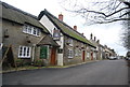
Crown Inn, Puncknowle
Grade II listed. http://www.britishlistedbuildings.co.uk/en-400683-crown-inn-puncknowle
Image: © N Chadwick
Taken: 29 Dec 2011
0.01 miles
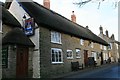
2
Puncknowle: Crown Inn from the west
Looking towards the Image from the southwest and including the pub sign.
Image: © Chris Downer
Taken: 24 Aug 2008
0.01 miles
3
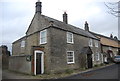
The Old Bakery, Church St
Grade II listed. http://www.britishlistedbuildings.co.uk/en-400684-the-old-bakery-puncknowle
Image: © N Chadwick
Taken: 29 Dec 2011
0.01 miles
4
The Crown at Puncknowle
The village pub is situated at the centre of the village on the main street opposite the church.
Image: © Nigel Mykura
Taken: 18 Jan 2009
0.01 miles
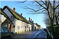
5
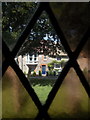
Puncknowle: a Church Street cottage
Looking through one of the church windows towards one of the cottages on the other side of Church Street.
Image: © Chris Downer
Taken: 14 May 2016
0.01 miles
7
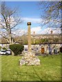
Old Central Cross - moved to Puncknowle churchyard
Puncknowle Cross, old shaft and base by the churchyard path, in parish of Puncknowle (West Dorset District), edge of churchyard, overlooking Church Street.
Grade II* Listed. List Entry Number: 1287939
https://historicengland.org.uk/listing/the-list/list-entry/1287939
Surveyed
Milestone Society National ID: DOWD_PUN
Image: © Milestone Society
Taken: Unknown
0.01 miles
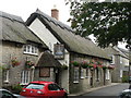
9
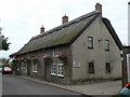
Puncknowle: Crown Inn
An attractive thatched pub in Church Street.
Image: © Chris Downer
Taken: 24 Aug 2008
0.02 miles
10
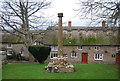
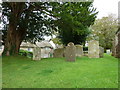
Village Cross, Puncknowle
Grade II* listed. http://www.britishlistedbuildings.co.uk/en-400691-village-cross-in-churchyard-4-metres-nor
In the background is The Crown Inn.
Image: © N Chadwick
Taken: 29 Dec 2011
0.02 miles