IMAGES TAKEN NEAR TO
Beech Road, DORCHESTER, DT2 8SZ
Introduction
This page details the photographs taken nearby to Beech Road, DT2 8SZ by members of the Geograph project.
The Geograph project started in 2005 with the aim of publishing, organising and preserving representative images for every square kilometre of Great Britain, Ireland and the Isle of Man.

There are currently over 7.5m images from over14,400 individuals and you can help contribute to the project by visiting https://www.geograph.org.uk
Image Map
Images are licensed for reuse under creativecommons.org/licenses/by-sa/2.0
Notes
- Clicking on the map will re-center to the selected point.
- The higher the marker number, the further away the image location is from the centre of the postcode.
Image Listing (155 Images Found)
Images are licensed for reuse under creativecommons.org/licenses/by-sa/2.0
Image
Details
Distance
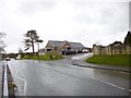
1
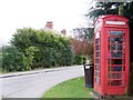
Telephone box, Puddletown
K6 telephone box on the edge of the village.
Image: © Maigheach-gheal
Taken: 22 Feb 2009
0.07 miles
2
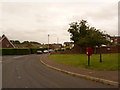
Puddletown: postbox № DT2 197, Brymer Road
This postbox stands more or less right on the gridline between this square and the one to the south, on Brymer Road, part of modern housing to the south of the village. The postbox is emptied finally at 10 o'clock each morning except Sunday.
Image: © Chris Downer
Taken: 13 Jun 2009
0.08 miles
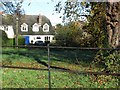
4
![Puddletown houses [1]](https://s3.geograph.org.uk/geophotos/06/77/26/6772627_a01baaed_120x120.jpg)
Puddletown houses [1]
Number 1 Athelhampton Road was partly used as a shop and as a garage. Built probably in the early 19th century with plastered walls and a thatched roof. The rear wing, along New Street was probably originally an outbuilding and was the part used as a shop. Listed, grade II, with details at: https://historicengland.org.uk/listing/the-list/list-entry/1154375
The village of Puddletown, earlier known as Piddletown is located alongside the River Piddle some 4½ miles north east of Dorchester and is now essentially a commuter village. There is evidence of occupation from prehistoric times in the form of some 30 round barrows. The use of watermeadows in Dorset was first developed in Puddletown in the 17th century. The village was the inspiration for the fictional settlement of Weatherbury in the novel Far from the Madding Crowd by Thomas Hardy.
Image: © Michael Dibb
Taken: 11 Dec 2020
0.10 miles
5

Puddletown, thatched cottage
No 1 Athelhampton Road; listed by English Heritage: http://www.imagesofengland.org.uk/Details/Default.aspx?id=106255&mode=adv
Image: © Mike Faherty
Taken: 15 Mar 2013
0.10 miles
6

Puddletown Surgery
On Athelhampton Road, at the corner of Milom Lane: http://www.puddletownsurgery.co.uk/
Image: © Mike Faherty
Taken: 15 Mar 2013
0.11 miles
7
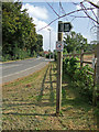
Start of the Public Byway from Puddletown to Ilsington
Image: © Mike Searle
Taken: 13 Sep 2007
0.12 miles
8
Puddletown Village Hall
On High Street, with Community Library to the left. http://www.dorsethalls.net/content/puddletown-village-hall-0 http://www.communitylibrarypuddletown.org/
Image: © Mike Faherty
Taken: 15 Mar 2013
0.13 miles
9
![Puddletown features [3]](https://s3.geograph.org.uk/geophotos/06/77/34/6773479_5649c0ca_120x120.jpg)
Puddletown features [3]
This gateway into the grounds of The Old Manor are seen from The Green.
The village of Puddletown, earlier known as Piddletown is located alongside the River Piddle some 4½ miles north east of Dorchester and is now essentially a commuter village. There is evidence of occupation from prehistoric times in the form of some 30 round barrows. The use of watermeadows in Dorset was first developed in Puddletown in the 17th century. The village was the inspiration for the fictional settlement of Weatherbury in the novel Far from the Madding Crowd by Thomas Hardy.
Image: © Michael Dibb
Taken: 11 Dec 2020
0.14 miles
10
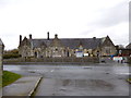
Puddletown, first school
Puddletown Church of England VC First School, on High Street; the building is dated 1864: http://www.puddletownfirst.dorset.sch.uk/pages/school/school.htm http://www.imagesofengland.org.uk/Details/Default.aspx?id=106263&mode=adv
Image: © Mike Faherty
Taken: 15 Mar 2013
0.15 miles