IMAGES TAKEN NEAR TO
The Common, DORCHESTER, DT2 8RD
Introduction
This page details the photographs taken nearby to The Common, DT2 8RD by members of the Geograph project.
The Geograph project started in 2005 with the aim of publishing, organising and preserving representative images for every square kilometre of Great Britain, Ireland and the Isle of Man.

There are currently over 7.5m images from over14,400 individuals and you can help contribute to the project by visiting https://www.geograph.org.uk
Image Map
Images are licensed for reuse under creativecommons.org/licenses/by-sa/2.0
Notes
- Clicking on the map will re-center to the selected point.
- The higher the marker number, the further away the image location is from the centre of the postcode.
Image Listing (5 Images Found)
Images are licensed for reuse under creativecommons.org/licenses/by-sa/2.0
Image
Details
Distance
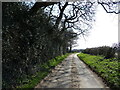
1
Moreton, Dorset
View of the road into the hamlet from Hurst.
Image: © Nigel Mykura
Taken: 1 Aug 2008
0.05 miles
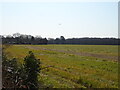
2
Fields at The Common, Moreton
View NE towards the river Frome from the westernmost end of the village.
Image: © Nigel Mykura
Taken: 1 Aug 2008
0.14 miles
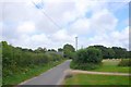
3
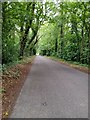
Tree lined road near Moreton, Dorset
Heading away from Moreton in the direction of Dorchester etc
Image: © Tim Marshall
Taken: 8 Jul 2020
0.18 miles