IMAGES TAKEN NEAR TO
Tincleton, DORCHESTER, DT2 8QP
Introduction
This page details the photographs taken nearby to DT2 8QP by members of the Geograph project.
The Geograph project started in 2005 with the aim of publishing, organising and preserving representative images for every square kilometre of Great Britain, Ireland and the Isle of Man.

There are currently over 7.5m images from over14,400 individuals and you can help contribute to the project by visiting https://www.geograph.org.uk
Image Map
Images are licensed for reuse under creativecommons.org/licenses/by-sa/2.0
Notes
- Clicking on the map will re-center to the selected point.
- The higher the marker number, the further away the image location is from the centre of the postcode.
Image Listing (8 Images Found)
Images are licensed for reuse under creativecommons.org/licenses/by-sa/2.0
Image
Details
Distance
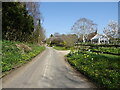
2
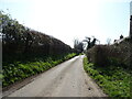
Tincleton Cross
View east along the road towards Ilsington and Dorchester
Image: © Nigel Mykura
Taken: 13 Jul 2008
0.04 miles
3
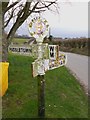
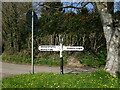
Old Direction Sign - Signpost by Tincleton Cross
Annulus finial - 4 arms; Dorset halo without NGR by the UC road, in parish of Tincleton (West Dorset District), Tincleton Cross, on large grass triangle.
Surveyed
Milestone Society National ID: DO_SY7692A
Image: © Milestone Society
Taken: Unknown
0.05 miles
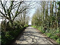
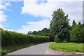
7
Tincleton Crossroads
Tincleton is a sleepy little backwater on the banks of the River Frome on the road that runs south from Puddletown across the meads and water meadows of the river.
Image: © Nigel Mykura
Taken: 11 May 2008
0.16 miles