IMAGES TAKEN NEAR TO
Broadmayne, DORCHESTER, DT2 8PW
Introduction
This page details the photographs taken nearby to DT2 8PW by members of the Geograph project.
The Geograph project started in 2005 with the aim of publishing, organising and preserving representative images for every square kilometre of Great Britain, Ireland and the Isle of Man.

There are currently over 7.5m images from over14,400 individuals and you can help contribute to the project by visiting https://www.geograph.org.uk
Image Map
Images are licensed for reuse under creativecommons.org/licenses/by-sa/2.0
Notes
- Clicking on the map will re-center to the selected point.
- The higher the marker number, the further away the image location is from the centre of the postcode.
Image Listing (5 Images Found)
Images are licensed for reuse under creativecommons.org/licenses/by-sa/2.0
Image
Details
Distance
1
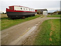
Ready for launch
Boat near outbuildings at Glebe Farm.
Image: © Peter Holmes
Taken: 17 Nov 2012
0.04 miles
2
Glebe Farm
Many of the farm buildings are converted to holiday cottages which look superb.
Image: © Stuart Cankett
Taken: 6 May 2007
0.04 miles
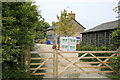
3
Track to Glebe Farm
Just south west of Broadmayne this track also leads to Holcombe Valley Holiday Cottages
Image: © Nigel Mykura
Taken: 22 Jul 2008
0.13 miles
4
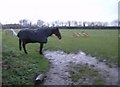
Cold, wet and nearly dark
One of the perils of trying to take pictures in the winter when nearly dark after a very wet day is the camera shutter speed. This horse at South Drive Farm is pretty fed up too, and does not have the option of going home to a warm bed. From the minor road crossing the south-west corner of the square, this picture looks west with the farm off to the right. This is a paddock, most of the square is criss-crossed with bridleways and gallops.
Image: © Graham Horn
Taken: 19 Nov 2007
0.22 miles
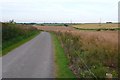
5
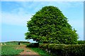
Countryside near Broadmayne
View west across the square from towards the tree that marks the southern end of Osminton Drove.
Image: © Nigel Mykura
Taken: 12 Apr 2009
0.23 miles